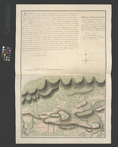
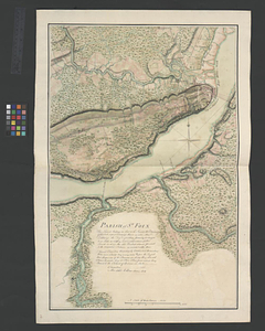
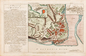
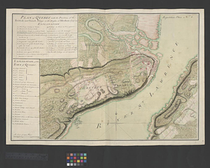
A correct plan of the environs of Quebec, and of the battle fought on the 13th September, 1759 : together with a particular detail of the French lines and batteries, and also of the encampments, batteries and attacks of the British army, and the investiture of that city under the command of Vice Admiral Saunders, Major General Wolfe, Brigadier General Monckton, and Brigadier General Townshend drawn from the original surveys taken by the engineers of the army

This map is also available in American Revolutionary Geographies Online (ARGO), a collections portal especially built for material relating to the American Revolutionary War Era. Visit ARGO to learn more about this item and explore the historical geography of North America in the late eighteenth century.
Item Information
- Title:
- A correct plan of the environs of Quebec, and of the battle fought on the 13th September, 1759 : together with a particular detail of the French lines and batteries, and also of the encampments, batteries and attacks of the British army, and the investiture of that city under the command of Vice Admiral Saunders, Major General Wolfe, Brigadier General Monckton, and Brigadier General Townshend drawn from the original surveys taken by the engineers of the army
- Contributor:
- Jefferys, Thomas, -1771
- Date:
-
[1768]
- Format:
-
Maps/Atlases
- Location:
- William L. Clements Library
- Collection (local):
-
William L. Clements Library Collection
- Subjects:
-
Québec Campaign, Québec, 1759--Maps
Québec (Québec)--Maps
United States--History--French and Indian War, 1754-1763--Maps
- Places:
-
CanadaQuebec (province)Québec
- Extent:
- 1 map with overlay : col. ; 41 x 89 cm
- Terms of Use:
-
The University of Michigan Library provides access to these materials for educational and research purposes. These materials may be under copyright. If you decide to use any of these materials, you are responsible for making your own legal assessment and securing any necessary permission. If you have questions about the collection, please contact the William L. Clements Library.
Contact host institution for more information.
- Publisher:
-
[London] :
Thos. Jefferys, the corner of St. Martins Lane Charing Cross
- Scale:
-
Scale 1:18,500.
- Language:
-
English
- Catalog Record:
-
Catalog record
- Notes:
-
Engraved by: Thomas Jefferys, geographer to his majesty.
Published in: A general topography of North America, London, 1768.
Overlay provides details of changed position of British troops at the battle of September 13, 1759.
Map shows details of British and French positions during the siege of Québec and table of references identifies British military units.
- Notes (date):
-
This date is inferred.
- Identifier:
-
591
- Barcode:
-
B1938060