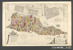
The United States of North America with the British & Spanish territories according to the treaty

This map is also available in American Revolutionary Geographies Online (ARGO), a collections portal especially built for material relating to the American Revolutionary War Era. Visit ARGO to learn more about this item and explore the historical geography of North America in the late eighteenth century.
Item Information
- Title:
- The United States of North America with the British & Spanish territories according to the treaty
- Creator:
- Faden, William, 1749-1836
- Name on Item:
-
engrav'd by Wm. Faden
- Date:
-
1783
- Format:
-
Maps/Atlases
- Location:
- William L. Clements Library
- Collection (local):
-
William L. Clements Library Collection
- Subjects:
-
Canada--Maps
United States--Maps
Merchants--Pictorial works
Slavery--Pictorial works
- Places:
-
Canada
United States
- Extent:
- 1 map : col. ; 53.3 x 63.6 cm.
- Terms of Use:
-
The University of Michigan Library provides access to these materials for educational and research purposes. These materials may be under copyright. If you decide to use any of these materials, you are responsible for making your own legal assessment and securing any necessary permission. If you have questions about the collection, please contact the William L. Clements Library.
Contact host institution for more information.
- Publisher:
-
[London] :
[William Faden]
- Scale:
-
Scale 1:6,500,000.
- Language:
-
English
- Catalog Record:
-
Catalog record
- Notes:
-
Sectioned and backed with linen.
Cartouche includes scene of British merchants and slaves loading a boat.
- Identifier:
-
825
- Barcode:
-
B1940892