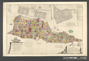
Tilforladelig kort over eylandet St. Croix udi America : saaledes som det ved en acurat udmaaling er befunden met quarterernes nayne og enhver plantagies nummer estler hvilke de udi matriculen findes indeforte og til enhver kiöber cederet beliggende paa 17 grader 38 minuter norder brefe
This map is also available in American Revolutionary Geographies Online (ARGO), a collections portal especially built for material relating to the American Revolutionary War Era. Visit ARGO to learn more about this item and explore the historical geography of North America in the late eighteenth century.
Item Information
- Title:
- Tilforladelig kort over eylandet St. Croix udi America : saaledes som det ved en acurat udmaaling er befunden met quarterernes nayne og enhver plantagies nummer estler hvilke de udi matriculen findes indeforte og til enhver kiöber cederet beliggende paa 17 grader 38 minuter norder brefe
- Title (alt.):
-
Tegning til byen Friderichstæd
Tegning over beyen Christianstæd
- Contributor:
- De Lode, Odvardt Helmoldt, approximately 1726-1757
- Creator:
- Beck, Jens Michelsen
- Name on Item:
-
tegnet af I.M. Beck
- Date:
-
1754
- Format:
-
Maps/Atlases
- Location:
- William L. Clements Library
- Collection (local):
-
William L. Clements Library Collection
- Subjects:
-
Real property--Virgin Islands--Saint Croix--Maps
Slavery--Pictorial works
Saint Croix (United States Virgin Islands)--Maps
Christiansted (United States Virgin Islands)--Maps
Frederiksted (United States Virgin Islands)--Maps
Moltke, Adam Gottlob, 1710-1792
- Places:
-
Virgin Islands of the United States (territory)Saint Croix (island)
Virgin Islands of the United States (territory)Christiansted
Virgin Islands of the United States (territory)Frederiksted
- Extent:
- 1 map with ms. additions : col. ; 48.2 x 74.7 cm.
- Terms of Use:
-
The University of Michigan Library provides access to these materials for educational and research purposes. These materials may be under copyright. If you decide to use any of these materials, you are responsible for making your own legal assessment and securing any necessary permission. If you have questions about the collection, please contact the William L. Clements Library.
Contact host institution for more information.
- Place of origin:
-
Haffiniæ [Copenhagen]
- Scale:
-
Scales vary.
- Language:
-
Danish
- Catalog Record:
-
Catalog record
- Notes:
-
Engraved by: O.H. de Lode.
Dedicated to Adam Gotlob Moltke.
Detailed cadastral map of island showing individual properties and locations of windmills.
Map officially updated in manuscript in 1767 to give names of all property owners and locations of sugar mills added since original publication in 1754. Manuscript additions made to northwest coast of island as well.
Includes manuscript tabulation of number and general location of all windmills.
Insets are plans of two principal towns on the island. Plan of Christiansted has been updated by manuscript addition of street names.
Cartouche shows a slave, sugar cane, and bundles of produce of the island.
- Identifier:
-
9140
- Barcode:
-
B3649513


