A map of the British and French settlements in North America

This map is also available in American Revolutionary Geographies Online (ARGO), a collections portal especially built for material relating to the American Revolutionary War Era. Visit ARGO to learn more about this item and explore the historical geography of North America in the late eighteenth century.
Item Information
- Title:
- A map of the British and French settlements in North America
- Title (alt.):
-
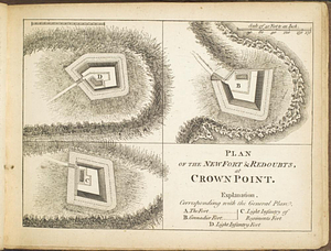
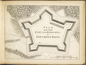
Fort Frederick at Crown Point built by the French 1731
- Creator:
- Hinton, John, -1781
- Date:
-
[1755]
- Format:
-
Maps/Atlases
- Location:
- William L. Clements Library
- Collection (local):
-
William L. Clements Library Collection
- Subjects:
-
East (U.S.)--Maps
Crown Point (N.Y.)--Maps
Fort Saint Frederic (Crown Point, N.Y.)--Maps
United States--History--French and Indian War, 1754-1763--Maps
Society of Anti-Gallicans
- Places:
-
Eastern United States (area)
New YorkEssex (county)Crown Point
- Extent:
- 1 map : col. ; 27.8 x 38 cm
- Terms of Use:
-
The University of Michigan Library provides access to these materials for educational and research purposes. These materials may be under copyright. If you decide to use any of these materials, you are responsible for making your own legal assessment and securing any necessary permission. If you have questions about the collection, please contact the William L. Clements Library.
Contact host institution for more information.
- Publisher:
-
[London] :
Univ. Mag. J. Hinton Newgate Street
- Scale:
-
Scale [1:12,500,000].
- Language:
-
English
- Catalog Record:
-
Catalog record
- Notes:
-
Shows provincial boundaries and identifies important forts.
Similar to map produced by the Society of Anti-Gallicans.
Below title: Universal magazine.
- Notes (date):
-
This date is inferred.
- Identifier:
-
209
- Barcode:
-
B1936529