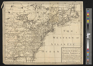
A new and accurate map of the English empire in North America : representing their rightful claim as confirm'd by charters, and the formal surrender of their Indian friends; likewise the encroachments of the French, with the several forts they have unjustly erected therein

This map is also available in American Revolutionary Geographies Online (ARGO), a collections portal especially built for material relating to the American Revolutionary War Era. Visit ARGO to learn more about this item and explore the historical geography of North America in the late eighteenth century.
Item Information
- Title:
- A new and accurate map of the English empire in North America : representing their rightful claim as confirm'd by charters, and the formal surrender of their Indian friends; likewise the encroachments of the French, with the several forts they have unjustly erected therein
- Title (alt.):
-
Plan of the town of Quebeck
Plan of the harbour of Annapolis Royal
Plan of Port Dauphin on the isle of Cape Briton
Fort Frederick built by the French at Crown or Scalp Point in the year 1731
Plan of the harbour and town of Louisbourg on the isle of Cape Briton
Plan of Chebucto harbour
- Contributor:
- Sayer, Robert, 1725-1794
- Contributor:
- Herbert, William, 1718-1795
- Creator:
- Society of Anti-Gallicans
- Name on Item:
-
by a Society of Anti-Gallicans
- Date:
-
December 1755
- Format:
-
Maps/Atlases
- Location:
- William L. Clements Library
- Collection (local):
-
William L. Clements Library Collection
- Subjects:
-
East (U.S.)--Maps
Canada, Eastern--Maps
United States--History--French and Indian War, 1754-1763--Maps
Québec (Québec)--Maps
Annapolis Royal (N.S.)--Maps
Fort Dauphin (N.S.)--Maps
Fort Saint Frederic (Crown Point, N.Y.)--Maps
Louisbourg (N.S.)--Maps
Halifax (N.S.)--Maps
Atlantic Ocean--Maps
- Places:
-
Eastern United States (area)
Canada
CanadaQuebec (province)Québec
CanadaNova Scotia (province)Annapolis Royal
CanadaNova Scotia (province)Louisbourg
CanadaNova Scotia (province)Halifax
Atlantic Ocean
- Extent:
- 1 map : col. ; 43.5 x 81.3 cm.
- Terms of Use:
-
The University of Michigan Library provides access to these materials for educational and research purposes. These materials may be under copyright. If you decide to use any of these materials, you are responsible for making your own legal assessment and securing any necessary permission. If you have questions about the collection, please contact the William L. Clements Library.
Contact host institution for more information.
- Publisher:
-
[London] :
Sold by Wm. Herbert & Robt. Sayer over against Fetter Lane in Fleet Street
- Scale:
-
Scale 1:7,000,000. Scales of insets vary.
- Language:
-
English
- Catalog Record:
-
Catalog record
- Notes:
-
Shows English claims across North America.
Untitled inset shows North America in relation to Europe.
- Identifier:
-
823
- Barcode:
-
B1941075