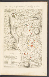
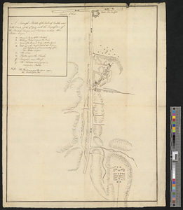
Ein grund-ris von der Festung Duquesne ...

This map is also available in American Revolutionary Geographies Online (ARGO), a collections portal especially built for material relating to the American Revolutionary War Era. Visit ARGO to learn more about this item and explore the historical geography of North America in the late eighteenth century.
Item Information
- Title:
- Ein grund-ris von der Festung Duquesne ...
- Date:
-
[ca. 1759]
- Format:
-
Maps/Atlases
- Location:
- William L. Clements Library
- Collection (local):
-
William L. Clements Library Collection
- Subjects:
-
Fort Duquesne (Pa.)--Maps
United States--History--French and Indian War, 1754-1763--Maps
- Places:
-
PennsylvaniaAllegheny (county)Pittsburgh
- Extent:
- 1 map ; 20.2 x 23 cm
- Terms of Use:
-
The University of Michigan Library provides access to these materials for educational and research purposes. These materials may be under copyright. If you decide to use any of these materials, you are responsible for making your own legal assessment and securing any necessary permission. If you have questions about the collection, please contact the William L. Clements Library.
Contact host institution for more information.
- Scale:
-
Scale indeterminate.
- Language:
-
German
- Catalog Record:
-
Catalog record
- Notes:
-
Printed as a broadside with a long, anti-war poem below map and on verso by a "preacher of the city of Darmstade."
- Identifier:
-
5545
- Barcode:
-
B1936572