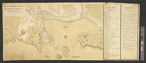
Map of the British landings at Louisbourg

This map is also available in American Revolutionary Geographies Online (ARGO), a collections portal especially built for material relating to the American Revolutionary War Era. Visit ARGO to learn more about this item and explore the historical geography of North America in the late eighteenth century.
Item Information
- Title:
- Map of the British landings at Louisbourg
- Title (alt.):
-
Line of battle
- Date:
-
[1758]
- Format:
-
Maps/Atlases
- Genre:
-
Manuscript maps
- Location:
- William L. Clements Library
- Collection (local):
-
William L. Clements Library Collection
- Subjects:
-
Tactics--Maps
Louisbourg (N.S.)--Maps
Louisbourg (N.S.)--History--Siege, 1758--Maps
United States--History--French and Indian War, 1754-1763--Maps
- Places:
-
CanadaNova Scotia (province)Louisbourg
- Extent:
- 1 ms. map : outline col. ; 6 x 14 cm
- Terms of Use:
-
The University of Michigan Library provides access to these materials for educational and research purposes. These materials may be under copyright. If you decide to use any of these materials, you are responsible for making your own legal assessment and securing any necessary permission. If you have questions about the collection, please contact the William L. Clements Library.
Contact host institution for more information.
- Scale:
-
Scale indeterminate.
- Language:
-
English
- Catalog Record:
-
Catalog record
- Notes:
-
Includes plan of British line of battle and information on naval and military forces involved in the siege of Louisbourg.
Pasted to Wight, E. An exact ground plan of Fort Edward.
Inset shows British line of battle for 1758 Louisbourg expedition with indivual regiments and brigade commanders identified.
- Notes (date):
-
This date is inferred.
- Identifier:
-
5544
- Barcode:
-
B1936569