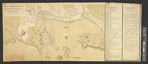
A survey of the city and fortress of Louisbourg, the harbour, and their environs, from Fresh Water Cove in Gabarouse Bay to about a mile to the eastward of the Light house Point : shewing the encampments of the several regiments during the time the place was besieged, with the redouts, batterys and approaches of the siege, as also the roads

This map is also available in American Revolutionary Geographies Online (ARGO), a collections portal especially built for material relating to the American Revolutionary War Era. Visit ARGO to learn more about this item and explore the historical geography of North America in the late eighteenth century.
Item Information
- Title:
- A survey of the city and fortress of Louisbourg, the harbour, and their environs, from Fresh Water Cove in Gabarouse Bay to about a mile to the eastward of the Light house Point : shewing the encampments of the several regiments during the time the place was besieged, with the redouts, batterys and approaches of the siege, as also the roads
- Contributor:
- Coombs, Richard
- Contributor:
- Bastide, John Henry, approximately 1700-1770
- Creator:
- Bontein, William
- Name on Item:
-
survey'd by Wm: Bontein engineer extraordinary
- Date:
-
[1758]
- Format:
-
Maps/Atlases
- Genre:
-
Manuscript maps
- Location:
- William L. Clements Library
- Collection (local):
-
William L. Clements Library Collection
- Subjects:
-
Louisbourg (N.S.)--Maps
Louisbourg (N.S.)--History--Siege, 1758--Maps
United States--History--French and Indian War, 1754-1763--Maps
- Places:
-
CanadaNova Scotia (province)Louisbourg
- Extent:
- 1 ms. map : col. ; 52 x 119 cm
- Terms of Use:
-
The University of Michigan Library provides access to these materials for educational and research purposes. These materials may be under copyright. If you decide to use any of these materials, you are responsible for making your own legal assessment and securing any necessary permission. If you have questions about the collection, please contact the William L. Clements Library.
Contact host institution for more information.
- Scale:
-
Scale 1:9,600.
- Language:
-
English
- Catalog Record:
-
Catalog record
- Notes:
-
Finished, colored, topographical map showing details of the fortress and the camps and siege works of the British.
Three tables of reference identify military units and events of the 1758 siege.
Survey made in aftermath of British capture of the fortress.
Signed below scale: Copy Rich: Coombs.
Surveyed under the direction of: Colo: Bastide chief engineer.
- Notes (date):
-
This date is inferred.
- Identifier:
-
8200
- Barcode:
-
B1938056