Toggle navigation
LMEC Home
Exhibitions
Georeferencing
Tools for Teachers
Collections
My Favorites
Sign Up / Log In
Search
Search the map portal
Map Collection
Map Collection
Map Sets
Search
Search
Search for
Search In
All Fields
Creator
Title
Subject
Place
Search All Digital Collections
Advanced Search
202 Results
My Search
Start Over
More Like
commonwealth:x633fb26h
Remove constraint More Like: commonwealth:x633fb26h
Filter your Search
Place
North and Central America
168
United States
141
Boston
99
Suffolk (county)
98
Boston Harbor
55
New England
34
World
19
Bunker Hill
15
more
Place
»
Topic
Boston (Mass.)--History--Revolution, 1775-1783--Maps--Early works to 1800
45
Boston Harbor (Mass.)--Maps--Early works to 1800
38
Fortification--Massachusetts--Boston--Maps--Early works to 1800
30
New England--Maps--Early works to 1800
28
Boston (Mass.)--Maps--Early works to 1800
24
Boston (Mass.)--Maps
20
World maps--Early works to 1800
19
Bunker Hill, Battle of, Boston, Mass., 1775--Maps--Early works to 1800
17
more
Topic
»
Date
Date range begin
–
Date range end
Current results range from
1493
to
1927
View distribution
Creator
Page, Thomas Hyde, Sir, 1746-1821
14
Aitken, Robert, 1735-1802
6
Faden, William, 1749-1836
6
Southack, Cyprian, 1662-1745
6
United States Coast Survey
6
Des Barres, Joseph F. W. (Joseph Frederick Wallet), 1722-1824
5
Robert Sayer and John Bennett (Firm)
5
Williams, Richard, active 1750-1776
5
more
Creator
»
Format
Maps/Atlases
198
Manuscripts
14
Drawings/Illustrations
3
Prints
1
Georeferenced
Yes
33
No
169
Collection
Norman B. Leventhal Map Center Collection
168
Mapping Boston Collection
139
Boston and New England Maps
101
American Revolutionary War-Era Maps
94
Maritime Charts and Atlases
32
Urban Maps
31
Richard H. Brown Revolutionary War Map Collection at Mount Vernon
19
Library of Congress Collection
11
more
Collection
»
Available to use
Creative Commons license
171
No known restrictions
31
Search Constraints
Sort by relevance
relevance
title
date (asc)
date (desc)
Number of results to display per page
100 per page
10
per page
20
per page
50
per page
100
per page
View results as:
grid view
map view
Search Results
1.
Boston et ses environs
2.
Plan de la ville et du port de Boston : capitale de la Nouvelle Angleterre : erigée prémierement en 1630, et en 1735 elle fut...
3.
Carte du port et havre de Boston avec les côtes adjacentes, dans laquel on a tracée les camps et les retranchemens occupé,...
4.
Carte du port et havre de Boston avec les côtes adjacentes, dans laquel on a tracée les camps et les retranchemens occupé,...
5.
Boston, its environs and harbour, with the rebels works raised against that town in 1775
6.
Carte von dem Hafen und der Stadt Boston : mit den umliegenden Gegenden und der Lägern sowohl der Americaner als auch des...
7.
Exact plan of General Gage's lines on Boston Neck in America
8.
Map of the environs of Boston
9.
A plan of Boston, and its environs : shewing the true situation of His Majesty's army, and also those of the rebels
10.
A plan of Boston in New England with its environs : including Milton, Dorchester, Roxbury, Brooklin, Cambridge, Medford,...
11.
A plan of the town of Boston, with the intrenchments &c. of His Majestys forces in 1775 : from the observations of Lieut. Page...
12.
Boston, S. West part : No. 25
13.
Carte von dem Hafen und der Stadt Boston : mit den umliegenden Gegenden und der Lägern sowohl der Americaner als auch des...
14.
Exact plan of General Gage's lines on Boston Neck in America
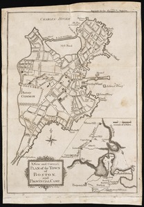
15.
A new and correct plan of the town of Boston, and provincial camp
16.
A plan of Boston, and its environs : shewing the true situation of His Majesty's army, and also those of the rebels
17.
A plan of Boston in New England with its environs : including Milton, Dorchester, Roxbury, Brooklin, Cambridge, Medford,...
18.
A plan of Boston in New England with its environs : including Milton, Dorchester, Roxbury, Brooklin, Cambridge, Medford,...
19.
A plan of the town of Boston with the intrenchments & ca. of His Majesty's forces in 1775 : from the observations of Lieut....
20.
A plan of the town of Boston, with the intrenchments &c. of His Majestys forces in 1775 : from the observations of Lieut. Page...
21.
Boston with its environs
22.
Baye et port de Boston
23.
Boston Harbour in New England
24.
Carte particuliere du havre de Boston : avec les sondes les bancs de Sable, les rochers les Amaies et les autres directions...
25.
Carte particuliere du havre de Boston : avec les sondes les bancs de Sable, les rochers les Amaies et les autres directions...
26.
A chart of the harbour of Boston
27.
Hafen von Boston
28.
A large draught of New England, New York and Long Island
29.
A new suruey of the harbour of Boston in New England
30.
Plan de Boston avec les sondes et les directions pour la navigation : traduit de l'anglais
31.
A plan of the town and chart of the harbour of Boston exhibiting a view of the islands, castle forts, and entrances into the...
32.
A new and correct plan of the town of Boston
33.
A plan of the action at Bunkers Hill, on the 17th. of June, 1775 : between His Majesty's troops under the command of Major...
34.
A plan of the action at Bunkers Hill, on the 17th. of June, 1775 : between His Majesty's troops under the command of Major...
35.
A plan of the action at Bunkers Hill on the 17th of June 1775 between His Majesty's troops, under the command of Major General...
36.
Plan of the battle, on Bunker's Hill : fought on the 17th of June 1775
37.
A sketch of the action between the British forces and the American provincials, on the heights of the peninsula of Charlestown,...
38.
Boston, its environs and harbour : with the rebels works raised against that town in 1775
39.
Exact plan of General Gage's lines on Boston Neck in America
40.
Exact plan of General Gage's lines on Boston Neck in America
41.
Fort on Dorc̃ester Point
42.
Fort on the first hill in Dorc̃ester : Fort on the second hill in Dorc̃ester
43.
A new and correct plan of the town of Boston
44.
A Plan oe [i.e. of] the British lines on Boston Neck in August 1775
45.
Plan of Boston & vicinity
46.
[Plan of the Neck and environs]
47.
[Rough draught of Boston and harbour]
48.
Baye et port de Boston
49.
Boston, its environs and harbour, with the rebel works raised against that town in 1775 : from the observations of Lieut. Page...
50.
Boston, with its environs
51.
Bowles's map of the seat of war in New England, comprehending the provinces of Massachusets Bay, and New Hampshire : with the...
52.
Carta rappresentante il porto di Boston
53.
Carte de la ville, baye et environs de Baston
54.
Carte des environs de Boston, capitale de la Nlle. Angleterre en Amerique
55.
A chart of the harbour of Boston
56.
A chart of the harbour of Boston
57.
A chart of the harbour of Boston
58.
A chart of the Harbour of Boston, with the soundings, sailing-marks, and other directions
59.
A chart of the Harbour of Boston, with the soundings, sailing-marks, and other directions
60.
A draught of Boston Harbor by Capt. Cyprian Southake
61.
A map of the most inhabited part of New England : containing the provinces of Massachusets Bay and New Hampshire, with the...
62.
A map of the most inhabited part of New England : containing the provinces of Massachusets Bay and New Hampshire, with the...
63.
A map of the most inhabited part of New England : containing the provinces of Massachusets Bay and New Hampshire, with the...
64.
A new and accurate chart of the harbour of Boston in New England in North America
65.
A new and accurate plan of the town of Boston in New England : A new plan of Boston Harbor from an actual survey
66.
Plan de la ville de Boston et ses environs
67.
A plan of the town and harbour of Boston : and the country adjacent with the road from Boston to Concord, shewing the place of...
68.
The seat of war, in New England, by an American volunteer : with the marches of the several corps sent by the colonies, towards...
69.
The seat of war in New England, by an American volunteer : with the marches of the several corps sent by the Colonies towards...
70.
The seat of war in New England, by an American volunteer : with the marches of the several corps sent by the Colonies towards...
71.
An accurate map of the country round Boston in New England from the best authorities
72.
An accurate map of the country round Boston in New England from the best authorities
73.
[Map of Boston]
74.
A Map of forty miles north, thirty miles west, and twentyfive miles south of Boston : including an accurate draft of the...
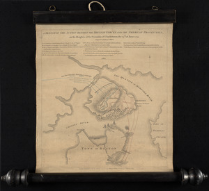
75.
Order of battle of the army under the command of Lt. General Gage at Boston, July 17th, 1775
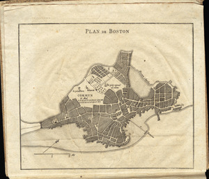
76.
Plan de Boston
77.
A plan of the action at Breeds Hill, on the 17th of June 1775 : between the American forces and the British troops :...
78.
A plan of the action at Bunkers Hill, on the 17th. of June, 1775 : between His Majesty's troops under the command of Major...
79.
A plan of the action at Bunkers Hill on the 17th of June 1775 between His Majesty's troops, under the command of Major General...
80.
A plan of the action at Bunkers Hill on the 17th of June 1775 between His Majesty's troops, under the command of Major General...
81.
Plan of the battle, on Bunker's Hill : fought on the 17th of June 1775
82.
Plan of the town of Boston with the attack on Bunkers-Hill in the peninsula of Charlestown the 17th of June 1775
83.
Plan of the town of Boston, with the attack on Bunkers-Hill, in the peninsula of Charlestown, the 17th of June, 1775
84.
Situations plan der Englischen Armée vor und um Boston nebst der stellung der Americaner
85.
A sketch of the action between the British forces and the American provincials, on the heights of the peninsula of Charlestown,...
86.
[The burnt ruins of Charlestown from across the Charles River]
87.
[Troops on parade, the Charles River and Castle Island]
88.
[View of the Charles River]
89.
The able doctor; or America swallowing the bitter draught
90.
An accurate map of North America : describing and distinguishing the British and Spanish dominions on this great continent :...
91.
An accurate map of the four New England states : shewing in a distinct manner all the mountains, forts, rivers, swamps,...
92.
An actual survey of the sea coast from New York to the I. Cape Brition : with tables of the direct and thwart courses &...
93.
Americae siue noui orbis, noua descriptio
94.
Americae siue noui orbis, noua descriptio
95.
Belgii Novi, Angliae Novae, et partis Virginiae : novissima delineatio
96.
Boston
97.
Boston
98.
Boston
99.
Boston and adjacent cities
100.
Boston and its environs
‹ Prev
Next ›
1
2
3


![A Plan oe [i.e. of] the British lines on Boston Neck in August 1775](https://bpldcassets.blob.core.windows.net/derivatives/images/commonwealth:z603vj41n/image_thumbnail_300.jpg)

![[Plan of the Neck and environs]](https://bpldcassets.blob.core.windows.net/derivatives/images/commonwealth:z603vj436/image_thumbnail_300.jpg)
![[Rough draught of Boston and harbour]](https://bpldcassets.blob.core.windows.net/derivatives/images/commonwealth:z603vj39m/image_thumbnail_300.jpg)


![[Map of Boston]](https://bpldcassets.blob.core.windows.net/derivatives/images/commonwealth:z603vw17n/image_thumbnail_300.jpg)


![[The burnt ruins of Charlestown from across the Charles River]](https://bpldcassets.blob.core.windows.net/derivatives/images/commonwealth:dz010v71m/image_thumbnail_300.jpg)
![[Troops on parade, the Charles River and Castle Island]](https://bpldcassets.blob.core.windows.net/derivatives/images/commonwealth:dz010v69k/image_thumbnail_300.jpg)
![[View of the Charles River]](https://bpldcassets.blob.core.windows.net/derivatives/images/commonwealth:dz010v735/image_thumbnail_300.jpg)


