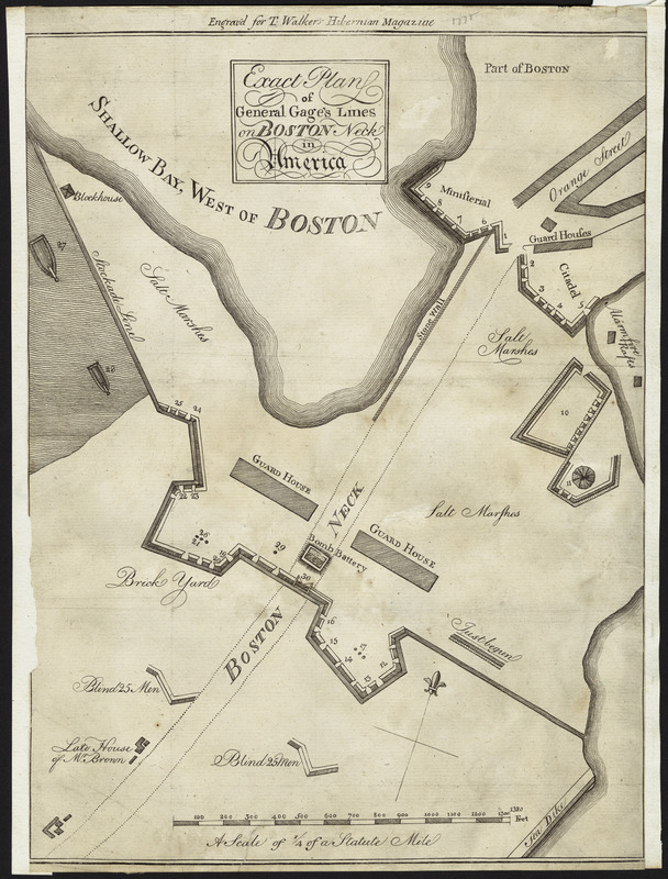
Exact plan of General Gage's lines on Boston Neck in America
This map is also available in American Revolutionary Geographies Online (ARGO), a collections portal especially built for material relating to the American Revolutionary War Era. Visit ARGO to learn more about this item and explore the historical geography of North America in the late eighteenth century.
Item Information
- Title:
- Exact plan of General Gage's lines on Boston Neck in America
- Description:
-
Based on a map published in the Pennsylvania Magazine (August 1775), this is one of the few maps to show how the British set up their blockade on Boston Neck. The blockade was designed to protect English troops in Boston from attack by the Americans, and further punish New Englanders by obstructing the only land route to their major port. In the accompanying article, it was noted that “this is a true state this day, July 31, 1775,” and that by using this map, “it will be easy to form a perfect idea of the manner in which the General hath blockaded the entrances” into Boston.
- Creator:
- Walker, Thomas
- Contributor:
- Gage, Thomas, 1721-1787
- Contributor:
- Aitken, Robert, 1735-1802
- Name on Item:
-
Engrav'd for T. Walker's Hibernian Magazine
- Date:
-
1775
- Format:
-
Maps/Atlases
- Location:
- Private Collection
- Collection (local):
-
Mapping Boston Collection
- Subjects:
-
Fortification--Massachusetts--Boston--Maps--Early works to 1800
Boston (Mass.)--History--Revolution, 1775-1783--Maps--Early works to 1800
- Places:
-
MassachusettsSuffolk (county)Boston
- Extent:
- 1 map ; 30 x 23 cm.
- Terms of Use:
-
No known copyright restrictions.
This work is licensed for use under a Creative Commons Attribution Non-Commercial Share Alike License (CC BY-NC-SA).

- Publisher:
-
Dublin :
[s.n.]
- Scale:
-
Scale ca. 1:3,500
- Language:
-
English
- Notes:
-
Relief shown by hachures. Depths shown by form lines.
Oriented with north towards the upper right.
- Identifier:
-
06_01_001135
- Barcode:
-
39999052507900


