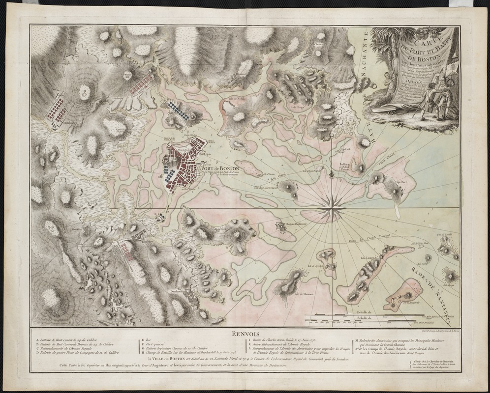
Carte du port et havre de Boston avec les côtes adjacentes, dans laquel on a tracée les camps et les retranchemens occupé, tant par les Anglois que par les Américains
This map is also available in American Revolutionary Geographies Online (ARGO), a collections portal especially built for material relating to the American Revolutionary War Era. Visit ARGO to learn more about this item and explore the historical geography of North America in the late eighteenth century.
Item Information
- Title:
- Carte du port et havre de Boston avec les côtes adjacentes, dans laquel on a tracée les camps et les retranchemens occupé, tant par les Anglois que par les Américains
- Description:
-
We Are One: This beautiful, meticulously-drawn French map of Boston's harbor and environs uses the Liberty Tree and liberty pole icons to champion the Americans' cause. In the decorative title cartouche, a Native American watches a Tory and Patriot struggle to gain possession of a liberty pole and a flag bearing the Liberty Tree image. Based on hydrographic and military surveys by British engineers, this topographic map highlights Boston’s distinctive geography. The harbor is filled with islands and dangerous sandbars, while the surrounding countryside is dotted with hills. For Frenchmen interested in recent political events, the map also locates the positions of British and American troops during the British siege of Boston.
Made in Boston: Highlighted on this fine topographic map of Boston and vicinity are the British and American troops. The American troops are colored red -- the first corps in Cambridge, the second corps opposite Charlestown neck, and the third corps near Roxbury. Among the many strategic topographic features so excellently rendered on this map is Dorchester Heights, which appears devoid of British defensive forces. This serious tactical error was ultimately recognized by General Washington, who occupied the Heights and forced the British to withdraw from the city on March 17, 1776. A note on the map reveals that it is based on an original plan of the siege drawn by order of the British government. Interestingly, the British fortifications on Boston Neck and Castle William Island are greatly exaggerated.
- Creator:
- Beaurain, Jean de, 1696-1771
- Name on Item:
-
dediée et presentée au Roi par ... le Chr. de Beaurain, geógraphe de sa majeste ; gravé P. Croisey ci-devant graveur de la marine.
- Date:
-
1776
- Format:
-
Maps/Atlases
- Location:
- Private Collection
- Collection (local):
-
Mapping Boston Collection
- Subjects:
-
Fortification--Massachusetts--Boston--Maps--Early works to 1800
Boston Harbor (Mass.)--Maps--Early works to 1800
Boston (Mass.)--History--Revolution, 1775-1783--Maps--Early works to 1800
- Places:
-
MassachusettsBoston Harbor
MassachusettsSuffolk (county)Boston
- Extent:
- 1 map : hand col. ; 56 x 70 cm.
- Terms of Use:
-
No known copyright restrictions.
This work is licensed for use under a Creative Commons Attribution Non-Commercial Share Alike License (CC BY-NC-SA).

- Publisher:
-
Paris :
Chez le Chevalier de Beaurain
- Scale:
-
Scale [ca. 1:25,000]
- Language:
-
French
- Notes:
-
Relief shown by hachures.
Depths shown by soundings.
"Cette carte à été copié sur un plan original apporté à la cour d'Angleterre ..."
Shows location of British and American forces.
Indexed for points of interest.
This map can be viewed as a georeferenced overlay in an interactive application made especially for We Are One: Mapping America's Road from Revolution to Independence http://d2o8owo4k087al.cloudfront.net/index.html?mapId=2.
- Notes (exhibitions):
-
Exhibited: "We Are One: Mapping America's Road from Revolution to Independence" organized by the Norman B. Leventhal Map Center at the Boston Public Library, 2015.
- Identifier:
-
06_01_001164
- Barcode:
-
39999052507876


