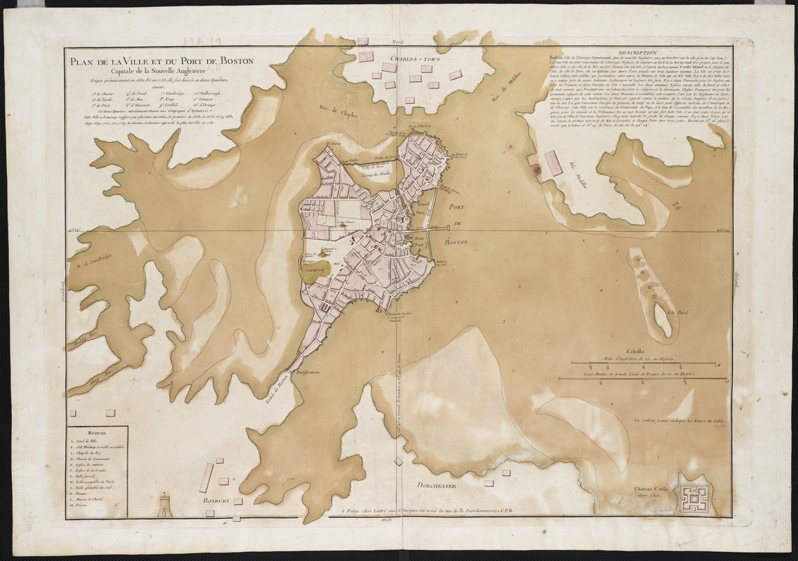
Plan de la ville et du port de Boston : capitale de la Nouvelle Angleterre : erigée prémierement en 1630, et en 1735 elle fut divisée en douze quartiers ... terrible en 1760
This map is also available in American Revolutionary Geographies Online (ARGO), a collections portal especially built for material relating to the American Revolutionary War Era. Visit ARGO to learn more about this item and explore the historical geography of North America in the late eighteenth century.
Item Information
- Title:
- Plan de la ville et du port de Boston : capitale de la Nouvelle Angleterre : erigée prémierement en 1630, et en 1735 elle fut divisée en douze quartiers ... terrible en 1760
- Description:
-
The talent and skill of Jean Lattré, a French publisher and engraver, are displayed in this attractive map of the immediate environs of Boston. The city and harbor command a sparse but forceful appearance in which the clarity of the engraving is complemented by the richness of the full wash color. The city itself is carefully rendered, with each existing street shown, including King Street extending inward from the Long Wharf toward the State House and site of the Boston Massacre. It is particularly useful in illustrating the circumstances of the Massacre and the days that followed, for it includes within the Harbor an inset of the fortified island upon which Castle William stood - the location to which the British regiments retreated according to Hutchinson's report.
- Creator:
- Lattré, Jean
- Name on Item:
-
Jean Lattré.
- Date:
-
[1764?]
- Format:
-
Maps/Atlases
- Location:
- Private Collection
- Collection (local):
-
Mapping Boston Collection
- Subjects:
-
Fortification--Massachusetts--Boston--Maps--Early works to 1800
Boston (Mass.)--History--Revolution, 1775-1783--Maps--Early works to 1800
Boston (Mass.)--Maps--Early works to 1800
Boston Harbor (Mass.)--Maps--Early works to 1800
- Places:
-
MassachusettsBoston Harbor
MassachusettsSuffolk (county)Boston
- Extent:
- 1 map : col. ; 66 x 47 cm.
- Terms of Use:
-
No known copyright restrictions.
This work is licensed for use under a Creative Commons Attribution Non-Commercial Share Alike License (CC BY-NC-SA).

- Publisher:
-
Paris :
Lattré
- Scale:
-
Scale [ca. 1:11,300]
- Language:
-
French
- Notes:
-
Relief shown pictorially.
Includes index to points of interest and description.
Attributed to Bellin in Boston Engineering Department's List of maps of Boston published between 1600 and 1903.
- Identifier:
-
06_01_001165
- Barcode:
-
39999052509401


