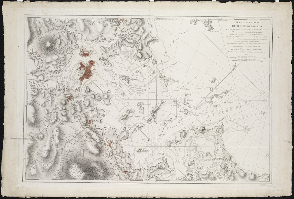
Carte particuliere du havre de Boston : avec les sondes les bancs de Sable, les rochers les Amaies et les autres directions utiles à la navigation
This map is also available in American Revolutionary Geographies Online (ARGO), a collections portal especially built for material relating to the American Revolutionary War Era. Visit ARGO to learn more about this item and explore the historical geography of North America in the late eighteenth century.
Item Information
- Title:
- Carte particuliere du havre de Boston : avec les sondes les bancs de Sable, les rochers les Amaies et les autres directions utiles à la navigation
- Description:
-
This detailed navigational chart shows shallows, sandbars, rocks, and other directions useful to ship captains trying to navigate their way through Boston Harbor. Clearly marked shoals within the harbor occupy present-day reclaimed and developed areas. By using techniques of shading and hachuring, the chart also portrays the inland terrain. It depicts roads, individual buildings, as well as small tracks of land. Published by the French Dépôt des Cartes et Plans de la Marine, this chart was based on one by English hydrographer Joseph Des Barres, which appeared in his Atlantic Neptune (1777-1781).
- Creator:
- Chabert, Joseph Bernard, marquis de, 1724-1805
- Name on Item:
-
réduite de la carte anglaise de J. E. S. Des Barres, écuyer ; la déclinaison de l'aiguille aimantée à été observée de 6d. 4'. N.O. en 8bre. 1778, par M. le marquis de Chabert qui à sussi déterminé à terre la latitude de divers points auxquels cette carte à été assujetie ; dressée au Dépôt Général des Cartes, Plans et Journaux de la marine ... par ordre de M. de Sartine ... petit, sculp.
- Date:
-
1780
- Format:
-
Maps/Atlases
- Location:
- Private Collection
- Collection (local):
-
Mapping Boston Collection
- Subjects:
-
Nautical charts--Massachusetts--Boston Harbor--Early works to 1800
Boston Harbor (Mass.)--Maps--Early works to 1800
Boston Bay (Mass.)--Maps--Early works to 1800
- Places:
-
MassachusettsBoston Harbor
- Extent:
- 1 map ; 67 x 92 cm.
- Terms of Use:
-
No known copyright restrictions.
This work is licensed for use under a Creative Commons Attribution Non-Commercial Share Alike License (CC BY-NC-SA).

- Publisher:
-
Paris :
Depot des Cartes et Plans de la Marine
- Scale:
-
Scale [ca. 1:33,000].
- Language:
-
French
- Notes:
-
Relief shown by hachures.
Depths shown by soundings.
Prime meridian: Paris.
"No. 336."
Appears in the Neptune Americo Septentrional. Paris, 1778-80.
- Identifier:
-
06_01_001168
- Barcode:
-
39999052507561


