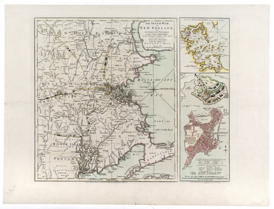
The seat of war, in New England, by an American volunteer : with the marches of the several corps sent by the colonies, towards Boston, with the attack on Bunkers-Hill
This map is also available in American Revolutionary Geographies Online (ARGO), a collections portal especially built for material relating to the American Revolutionary War Era. Visit ARGO to learn more about this item and explore the historical geography of North America in the late eighteenth century.
Item Information
- Title:
- The seat of war, in New England, by an American volunteer : with the marches of the several corps sent by the colonies, towards Boston, with the attack on Bunkers-Hill
- Publisher:
- Robert Sayer and John Bennett (Firm)
- Date:
-
1775
- Format:
-
Maps/Atlases
- Location:
- New-York Historical Society
- Collection (local):
-
New-York Historical Society Collection
- Subjects:
-
Harbors--Massachusetts--Boston--Maps--Early works to 1800
Bunker Hill, Battle of, Boston, Mass., 1775--Maps--Early works to 1800
New England--Maps--Early works to 1800
Boston Harbor (Mass.)--Maps--Early works to 1800
Boston (Mass.)--Maps--Early works to 1800
Charlestown (Boston, Mass.)--Maps--Early works to 1800
Boston (Mass.)--History--Siege, 1775-1776--Maps--Early works to 1800
United States--History--Revolution, 1775-1783--Maps--Early works to 1800
New England--History--Revolution, 1775-1783--Maps--Early works to 1800
- Places:
-
Boston Harbor
- Extent:
- 1 map : color ; 45 x 53 cm
- Terms of Use:
-
No known copyright restrictions.
No known restrictions on use.
- Publisher:
-
London :
Printed for R. Sayer & J. Bennett, no. 53 Fleet Street as the act directs
- Scale:
-
Scale ca. 1:450,000
- Language:
-
English
- Catalog Record:
-
https://library.nyu.edu/persistent/lcn/nyu_aleph004265015?institution=NYU&persistent
- Notes:
-
Prime meridian: Boston.
Relief shown by hachures.
Map of New England shows routes of march and encampments of colonial forces towards Boston.
Movements of Battle of Bunker Hill shown by illustrations of troops and the burning of Charlestown.
Text and table of references with inset map of Boston provide additional information about the city.
Insets: Plan of Boston Harbour, from an actual survey--Plan of the town of Boston with the attack on Bunkers-Hill in the peninsula of Charlestown, the 17th of June 1775.
Insets are an addition to the main map from a separate plate with same imprint date.
- Notes (citation):
-
LC Maps of North America, 1750-1789, 813
Nebenzahl, Kenneth. A bibliography of printed battle plans, nos. 6 and 6a
- Identifier:
-
93227d_SeatWarNewEngland1775_M20_3_9


