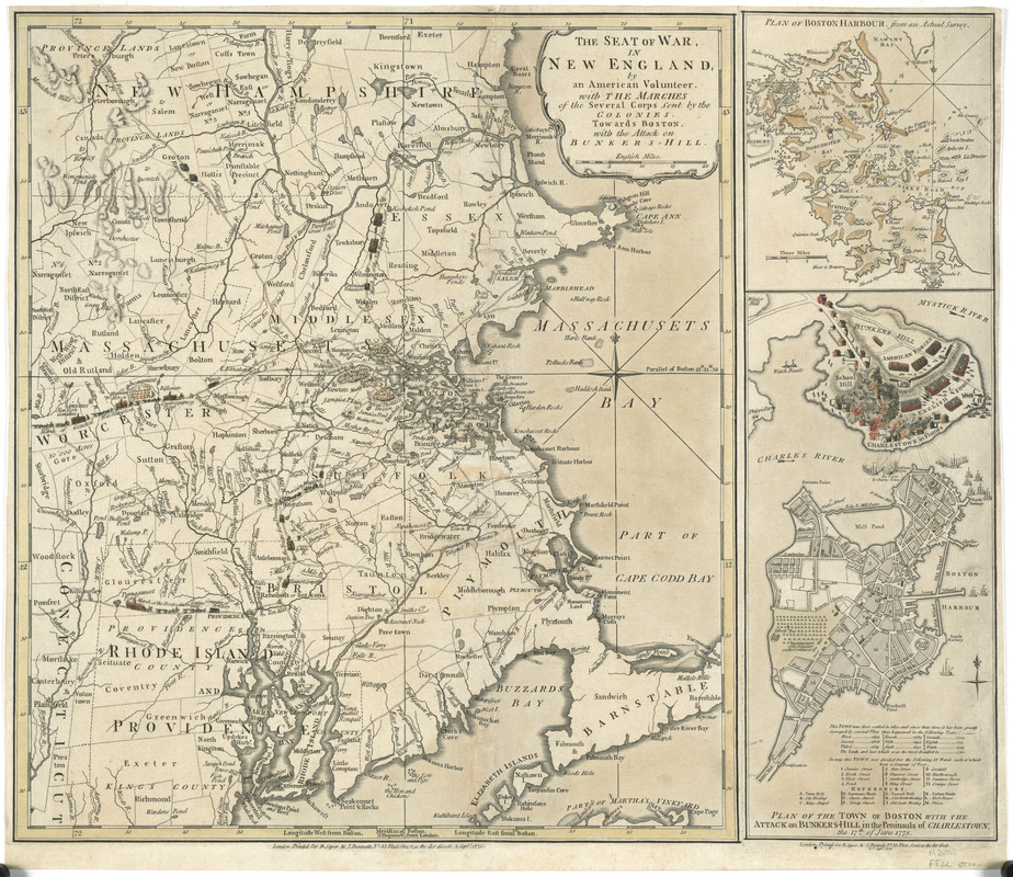
The seat of war in New England, by an American volunteer : with the marches of the several corps sent by the Colonies towards Boston, with the attack on Bunkers-Hill
This map is also available in American Revolutionary Geographies Online (ARGO), a collections portal especially built for material relating to the American Revolutionary War Era. Visit ARGO to learn more about this item and explore the historical geography of North America in the late eighteenth century.
Item Information
- Title:
- The seat of war in New England, by an American volunteer : with the marches of the several corps sent by the Colonies towards Boston, with the attack on Bunkers-Hill
- Title (alt.):
-
Plan of Boston Harbour, from an actual survey
Plan of the town of Boston with the attack on Bunkers-Hill in the peninsula of Charlestown, the 17th of June, 1775
- Description:
-
This map, a copy of which appeared in George Washington's personal collection, was printed in early September 1775 - just three months after the Battle of Bunker Hill. The main map shows the march of soldiers through central Massachusetts, northern Connecticut, southern New Hampshire and Rhode Island to Cambridge. Washington's entourage - complete with cannons - approaches from the west, and their skirmish in Concord is marked on the map by two crossed swords. The Battle of Bunker Hill is detailed in the bottom left, while the Boston Harbor islands are illustrated in the top right portion.
- Contributor:
- Robert Sayer and John Bennett (Firm)
- Date:
-
1775
- Format:
-
Maps/Atlases
- Location:
- George Washington's Mount Vernon
- Collection (local):
-
Richard H. Brown Revolutionary War Map Collection at Mount Vernon
- Subjects:
-
Bunker Hill, Battle of, Boston, Mass., 1775--Maps--Early works to 1800
New England--History--Revolution, 1775-1783--Maps--Early works to 1800
Boston (Mass.)--Maps--Early works to 1800
Boston Harbor (Mass.)--Maps--Early works to 1800
- Places:
-
Boston Harbor
Suffolk (county)BostonBunker Hill
- Extent:
- 1 map : hand col. ; 44 x 38 cm.
- Terms of Use:
-
No known copyright restrictions.
This work is licensed for use under a Creative Commons Attribution Non-Commercial Share Alike License (CC BY-NC-SA).

- Publisher:
-
London :
Printed for R. Sayer & J. Bennett
- Scale:
-
Scale [ca. 1:450,000]
- Language:
-
English
- Catalog Record:
-
MVLA record
- Notes:
-
Relief shown by hachures. Depths shown by soundings.
Prime meridians: Boston and London.
Includes "Plan of Boston Harbour, from an actual survey" and "Plan of the town of Boston with the attack on Bunkers-Hill in the peninsula of Charlestown, the 17th of June, 1775."
- Identifier:
-
06_01_008201
- LCCN:
-
gm 71002357