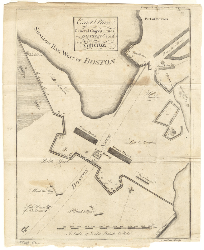
Exact plan of General Gage's lines on Boston Neck in America
This map is also available in American Revolutionary Geographies Online (ARGO), a collections portal especially built for material relating to the American Revolutionary War Era. Visit ARGO to learn more about this item and explore the historical geography of North America in the late eighteenth century.
Item Information
- Title:
- Exact plan of General Gage's lines on Boston Neck in America
- Title (alt.):
-
The Pennsylvania magazine, or, American monthly museum
- Creator:
- Gage, Thomas, 1721-1787
- Publisher:
- Aitken, Robert, 1735-1802
- Name on Item:
-
Aitken sculp.
- Date:
-
[1775]
- Format:
-
Maps/Atlases
- Location:
- George Washington's Mount Vernon
- Collection (local):
-
Richard H. Brown Revolutionary War Map Collection at Mount Vernon
- Subjects:
-
Fortification--Massachusetts--Boston--Maps--Early works to 1800
Boston (Mass.)--History--Revolution, 1775-1783--Maps--Early works to 1800
- Places:
-
Suffolk (county)Boston
- Extent:
- 1 map ; 30 x 23 cm.
- Terms of Use:
-
No known copyright restrictions.
This work is licensed for use under a Creative Commons Attribution Non-Commercial Share Alike License (CC BY-NC-SA).

- Publisher:
-
Philadelphia :
R. Aitken
- Scale:
-
Scale [ca. 1:3,325]
- Language:
-
English
- Catalog Record:
-
MVLA record
- Notes:
-
Relief shown by hachures. Depths shown by form lines.
Oriented with north towards the upper right.
"Engrav'd for the Pennsylv. Magazine."
From Pennylvania Magazine 1(1775), opposite page 358.
- Notes (date):
-
This date is inferred.
- Notes (citation):
-
Nebenzahl, K. Bibliography of printed battle plans, 5
- Identifier:
-
06_01_008514
- Barcode:
-
30000003816151


