Boston
This map is also available in American Revolutionary Geographies Online (ARGO), a collections portal especially built for material relating to the American Revolutionary War Era. Visit ARGO to learn more about this item and explore the historical geography of North America in the late eighteenth century.
Item Information
- Title:
- Boston
- Description:
-
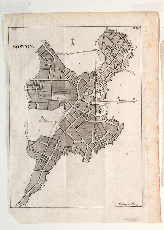
This plan of the town of Boston is one of an unrecorded pair of German engravings, originally printed in a book, pertaining to Boston. Together they present a detailed picture of the setting of the Boston Massacre and the town of Boston in the final decades of the eighteenth century. The town plan includes houses, buildings, wharves and the Boston Common. Mounted with "Hafen von Boston.
- Creator:
- Theil, J.
- Engraver:
- Gerstmayr
- Name on Item:
-
Gerstmayr sc.
- Date:
-
1780
- Format:
-
Maps/Atlases
- Location:
- Private Collection
- Collection (local):
-
Mapping Boston Collection
- Subjects:
-
Boston (Mass.)--Maps--Early works to 1800
- Places:
-
MassachusettsSuffolk (county)Boston
- Extent:
- 1 map ; 25 x 18 cm.
- Terms of Use:
-
No known copyright restrictions.
This work is licensed for use under a Creative Commons Attribution Non-Commercial Share Alike License (CC BY-NC-SA).

- Publisher:
-
Memmingen? :
[s.n.]
- Scale:
-
Scale not given
- Language:
-
English
- Notes:
-
Relief shown pictorially.
"III Taf." in upper right corner.
Mounted with Hafen von Boston.
- Identifier:
-
05_04_000067
- Barcode:
-
39999052509500


