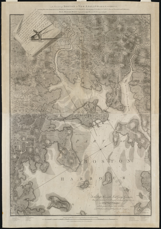
A plan of Boston in New England with its environs : including Milton, Dorchester, Roxbury, Brooklin, Cambridge, Medford, Charlestown, parts of Malden and Chelsea with the military works constructed in those places in the years 1775 and 1776
This map is also available in American Revolutionary Geographies Online (ARGO), a collections portal especially built for material relating to the American Revolutionary War Era. Visit ARGO to learn more about this item and explore the historical geography of North America in the late eighteenth century.
Item Information
- Title:
- A plan of Boston in New England with its environs : including Milton, Dorchester, Roxbury, Brooklin, Cambridge, Medford, Charlestown, parts of Malden and Chelsea with the military works constructed in those places in the years 1775 and 1776
- Description:
-
This most important battle plan of the New England theater of war shows, in detail, the American fortifications on Dorchester Heights forcing the British to leave Boston in 1776. This was the best printed plan of the city of Boston and its environs, to date. Pelham, a Loyalist, was born in Boston in 1748/9. The note that was engraved in the upper left of this map is a copy of the passport issued to Pelham two months after the Battle of Bunkers-Hill, giving him permission to examine the enemy lines. The aquatint is of interest, because of its high quality. It is known that Pelham consulted John Singleton Copley (Pelham's half brother) regarding the production of this map. Pelham was eleven years Copley's junior, and there is little question that Pelham learned to draw from his accomplished elder. The outstanding result is without question the finest cartographical print relating to the Revolutionary War.
- Creator:
- Pelham, Henry, 1749-1806
- Contributor:
- Jukes, Francis
- Name on Item:
-
engrav'd in aqua tinta by Francis Jukes
- Date:
-
1777
- Format:
-
Maps/Atlases
- Location:
- Private Collection
- Collection (local):
-
Mapping Boston Collection
- Subjects:
-
Fortification--Massachusetts--Boston--Maps--Early works to 1800
Boston (Mass.)--History--Revolution, 1775-1783--Maps--Early works to 1800
Boston (Mass.)--Buildings, structures, etc--Maps--Early works to 1800
- Places:
-
MassachusettsSuffolk (county)Boston
- Extent:
- 1 map ; 98 x 69 cm.
- Terms of Use:
-
No known copyright restrictions.
No known restrictions on use.
- Publisher:
-
London :
H. Pelham
- Scale:
-
Scale [ca. 1:14,000]
- Language:
-
English
- Notes:
-
Relief shown by shading.
Depths shown by soundings.
Includes facsimile of pass issued by James Urquhart, town major, to allow free passage of Henry Pelham "to take a plan of the towns of Boston & Charlestown and the rebel works round these places;" dedication "To the Right Honourable Lord George Germain ..." with autographed signature of Henry Pelham; and, index to points of interest in margin.
Oriented with north toward the upper right.
This map can be viewed as a georeferenced overlay in an interactive application made especially for We Are One: Mapping America's Road from Revolution to Independence http://d2o8owo4k087al.cloudfront.net/index.html?mapId=58.
- Notes (citation):
-
LC Maps and charts of North America and the West Indies 1750-1789, 935
Nebenzahl, K. Bibliography of printed battle plans of the American Revolution 1775-1795, 20
Phillips. List of Maps of America in the Library of Congress, p. 151
- Notes (exhibitions):
-
Exhibited: "We Are One: Mapping America's Road from Revolution to Independence" organized by the Norman B. Leventhal Map Center at the Boston Public Library, 2015.
Exhibited: "Faces & Places" organized by the Norman B. Leventhal Map Center at the Boston Public Library, 2003-2004.
- Identifier:
-
06_01_001179
- Barcode:
-
39999052509369


