Toggle navigation
LMEC Home
Exhibitions
Georeferencing
Tools for Teachers
Collections
My Favorites
Sign Up / Log In
Search
Search the map portal
Map Collection
Map Collection
Map Sets
Search
Search
Search for
Search In
All Fields
Creator
Title
Subject
Place
Search All Digital Collections
Advanced Search
147 Results
My Search
Start Over
More Like
commonwealth:j3860873k
Remove constraint More Like: commonwealth:j3860873k
Filter your Search
Place
United States
89
North and Central America
82
New England
21
North America
17
Massachusetts
16
Canada
15
Rhode Island
8
Middle Atlantic
7
more
Place
»
Topic
United States--Maps--Early works to 1800
60
North America--Maps--Early works to 1800
20
New England--Maps--Early works to 1800
16
Canada--Maps--Early works to 1800
13
World maps--Early works to 1800
13
America--Maps--Early works to 1800
9
Massachusetts--Maps
8
Middle Atlantic States--Maps--Early works to 1800
6
more
Topic
»
Date
Date range begin
–
Date range end
Current results range from
1482
to
1990
View distribution
Creator
Lodge, John, -1796
5
Ortelius, Abraham, 1527-1598
5
Bellin, Jacques Nicolas, 1703-1772
4
Robert Sayer and John Bennett (Firm)
4
Basset (Firm)
3
Bew, John, -1793
3
Bordon, Benedetto, 1450-1530
3
Denis, Louis, 1725-1794
3
more
Creator
»
Format
Maps/Atlases
147
Books
1
Georeferenced
Yes
13
No
134
Collection
Sidney R. Knafel Map Collection at Phillips Academy
87
American Revolutionary War-Era Maps
74
Norman B. Leventhal Map & Education Center Collection
29
New York Public Library Collection
15
Richard H. Brown Revolutionary War Map Collection at Mount Vernon
9
New-York Historical Society Collection
4
Mapping Boston Collection
2
Boston Athenaeum, Cartographic Collection
1
more
Collection
»
Available to use
No known restrictions
31
Creative Commons license
28
Search Constraints
Sort by relevance
relevance
title
date (asc)
date (desc)
Number of results to display per page
100 per page
10
per page
20
per page
50
per page
100
per page
View results as:
grid view
map view
Search Results
1.
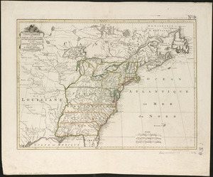
An accurate map of the United States of America : according to the Treaty of Peace of 1783
2.
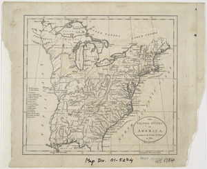
An accurate map of the United States of America, with part of the surrounding provinces agreeable to the Treaty of Peace of 1783
3.
L'Amerique Septentrionale, ou se remarquent les Etats Unis
4.
Amplissimae regionis Mississipi seu provinciae Ludovicianae â R.P. Ludovico Hennepin Francisc. Miss. in America septentrionali...
5.
Amplissimae regionis Mississipi seu Provinciae Ludovicianae â R.P. Ludovico Hennepin Francisc Miss in America Septentrionali...
6.
Bowles's new one-sheet map of the independent states of Virginia, Maryland, Delaware, Pensylvania, New Jersey, New York,...
7.
BOWLES'S NEW POCKET MAP OF THE UNITED STATES OF AMERICA : WITH THE BRITISH POSSESSIONS OF CANADA, NOVA SCOTIA, AND OF...
8.
British dominions in America, drawn from the latest and best authorities
9.
Carta della Nuova Inghilterra, Nuova Iork, e Pensilvania
10.
Carte de la Louisiane cours du Mississipi et pais voisins : dediée à M. le Comte de Maurepas, ministre et secretaire d'etat...
11.
Carte de la Louisiane et du cours de Mississipi
12.
Carte de la Louisiane et du cours du Mississipi avec les colonies anglaises
13.
Carte du Canada et des Etats-Unis de l'Amérique Septentrionale
14.
Carte du Mexique et des Etats Unis d'Amérique, partie meridionale
15.
Carte du theatre de la guerre presente en Amerique
16.
Carte du theatre de la guerre presente en Amerique
17.
Carte d'une partie de l'Amérique Septentrionale pour servir à l'intelligence du mémoire sur les prétentions des Anglois au...
18.
Carte generale des colonies angloises dans l'Amerique Septentrionale pour l'intelligence de la guerre presente : d'apres des...
19.
Carte générale des Etats Unis de l'Amérique Septentrionale : renfermant aussi quelques provinces Angloises adjacentes
20.
Carte génerale des Etats-Unis de l'Amérique Septentrionale : divisée en ses 17 provinces
21.
Carte generale des treize Etats Unis, de l'Amerique septentrionale = Kaart van de dertien Verénigde Staaten, in Noord Amerika
22.
Carte generale des treize Etats Unis, de l'Amerique septentrionale
23.
Carte minéralogique, où l'on voit la nature des terreins du Canada et de la Louisiane
24.
Carte nouvelle de l'Amérique Angloise contenant tout ce que les Anglois possédent sur le continent de l'Amérique...
25.
Carte réduite du nord des Etat-Unis avec l'intérieur du pays : pour servir à l'intelligence de cette histoire ; copieé par...
26.
Charte über die XIII Vereinigte Staaten von Nord-America
27.
A general map of the middle British colonies, in America : viz Virginia, Màriland, Dèlaware, Pensilvania, New-Jersey, New-York,...
28.
A general map of the middle British colonies, in America : viz Virginia, Màriland, Dèlaware, Pensilvania, New-Jersey,...
29.
Map for the interior travels through America : delineating the march of the army
30.
A map of Canada and the north part of Louisiana with the adjacent countrys
31.
A map of Carolana and of the river Meschacebe &c
32.
A Map of the British American plantations, extending from Boston in New England to Georgia : including all the back settlements...
33.
A map of the British and French dominions in North America : with the roads, distances, limits, and extent of the settlements,...
34.
A map of the northern and middle states : comprehending the western territory & the British dominions in North America : from...
35.
Map of the United States exhibiting the post-roads, the situations, connections & distances of the post-offices, stage roads,...
36.
Map of the United States in North America : with the British, French and Spanish dominions adjoining, according to the treaty...
37.
A map of the United States of America, as settled by the peace of 1783
38.
A map of the United States of N. America
39.
A map of the United States of North America : drawn from a number of critical researches
40.
A new and correct map of North America : in which the places of the principal engagements during the present war are accurately...
41.
A new and correct map of North America : in which the places of the principal engagements during the present war are accurately...
42.
A new and correct map of North America with the West India Islands : divided according to the last treaty of peace, concluded...
43.
A new and correct map of North America, with the West India islands, divided according to the preliminary articles of peace,...
44.
A new map of North America
45.
A New map of North America with the West India Islands : divided according to the preliminary articles of peace, signed at...
46.
A new map of the United States of North America with the British dominions on that continent &c
47.
Partie de l'Amérique septentrionale, qui comprend le cours de l'Ohio, la Nlle. Angleterre, la Nlle York, le New Jersey, la...
48.
Partie septentrionale des possessions angloise en Amérique : pour servire d'intelligence à la guerre présente entre les...
49.
Schauplatz des Kriegs zwischen Engelland und seinen Collonien in America
50.
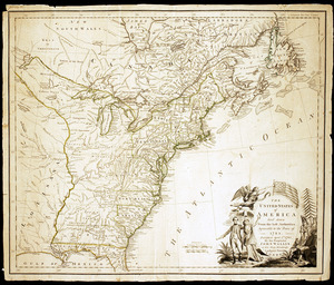
States of America, drawn from the best authorities
51.
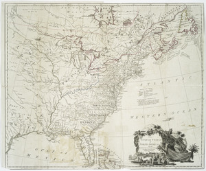
The United States of America, according to the Treaty of Peace of 1784
52.
The United States of America laid down from the best authorities, agreeable to the Peace of 1783
53.
The United States of America laid down from the best authorities, agreeable to the Peace of 1783
54.
The United States of America with the British possessions of Canada, Nova Scotia, & of Newfoundland, divided with the French :...
55.
The United States of America with the British possessions of Canada, Nova Scotia, & of Newfoundland, divided with the French :...
56.
The United States of America with the British possessions of Canada, Nova Scotia, New Brunswick and Newfoundland divided with...
57.
The United States of North America : with the British & Spanish territories according to the treaty
58.
The United States of North America : with the British territories and those of Spain according to the treaty of 1784
59.
The United States of North America, with the British & Spanish territories according to the treaty
60.
The United States of North America, with the British & Spanish territories according to the treaty
61.
An accurate map of Rhode Island, part of Connecticut and Massachusets, shewing Admiral Arbuthnot's station in blocking up...
62.
America
63.
America sive India Nova : ad magnae Gerardi Mercatoris aui universalis imitationem in compendium redacta
64.
America sive novvs orbis respectv Evropaeorvm inferior globi terrestris pars
65.
Americae pars Borealis, Florida, Baccalaos, Canada, Corterealis
66.
Americae siue noui orbis, noua descriptio
67.
Americae siue noui orbis, noua descriptio
68.
The American Atlas or, A Geographical Description of the whole continent of America : wherein are delineated at large, its...
69.
The American pilot : containing the navigation of the sea coat of North America . . .
70.
Atlantic Ocean
71.
L'Atlas de mer ou monde aquatique, remontrant toutes les côtes de la mer, a scavoir de la partie connuë de I'Univers, avec une...
72.
Barnstable County, Dukes County and Nantucket Island, Massachusetts
73.
Baye et port d'Yorc, capitale de la Nouvelle Yorc
74.
Bowles's new pocket map of the most inhabited part of New England : comprehending the provinces of Massachusets Bay and New...
75.
Carta marina nova tabula
76.
Carte de la Nouvelle Angleterre, New York, Pensilvanie et Nouveau Jersay suivant les cartes angloises
77.
Carte de la Nouvelle Angleterre, Nouvelle York, Nouvelle Jersey et Pensilvanie
78.
Chart and plan of the harbour of New York & the couny. adjacent, from Sandy Hook to Kingsbridge, comprehending the whole of New...
79.
Chart for the journal of Mr. le Mquis. de Chastellux
80.
A chart of the gulf stream
81.
Costes et rivieres de Virginie, de Mariland, et de Nouvelle Angletere
82.
The English pilot. The fourth book. Describing the West-India navigation, from Hudson's-Bay to the River Amazones. Particulary...
83.
Garden of Eden
84.
Generale Ptholemei
85.
Geological map of Massachusetts
86.
The harbor of Holmes' Hole
87.
Herbipolis occidens Wurtzpurg
88.
La heroike enterprinse faict par le Signeur Draeck d'avoir cirquit toute la terre
89.
A map of Massachusetts, from the best authorities
90.
Map of Massachusetts, from the best authorities
91.
A map of New England, New York, New Jersey and Pensilvania
92.
A map of New-England, being the first that ever was here cut, and done by the best pattern that could be had, which being in...
93.
A map of the British and French dominions in North America with the roads, distances, limits, and extent of the settlements,...
94.
Map of the Caribbean Area
95.
Map of the northern, or, New England states of America, comprehending Vermont, New Hampshire, District of Main, Massachusetts,...
96.
Map of the northern part of New England : compiled for Pres't. Dwight's travels
97.
A map of the province of Massachusets Bay and colony of Rhode Island, with part of Connecticut, New Hampshire, and Vermont
98.
Map of the southern part of New England : compiled for Pres't. Dwights travels
99.
Maris Pacifici (quod vulgo Mar del Zur) cum regionibus circumiacentibus, insulisque in eodem passim sparsis, novissima descriptio
100.
Massachusetts
‹ Prev
Next ›
1
2