Charte über die XIII Vereinigte Staaten von Nord-America
This map is also available in American Revolutionary Geographies Online (ARGO), a collections portal especially built for material relating to the American Revolutionary War Era. Visit ARGO to learn more about this item and explore the historical geography of North America in the late eighteenth century.
Item Information
- Title:
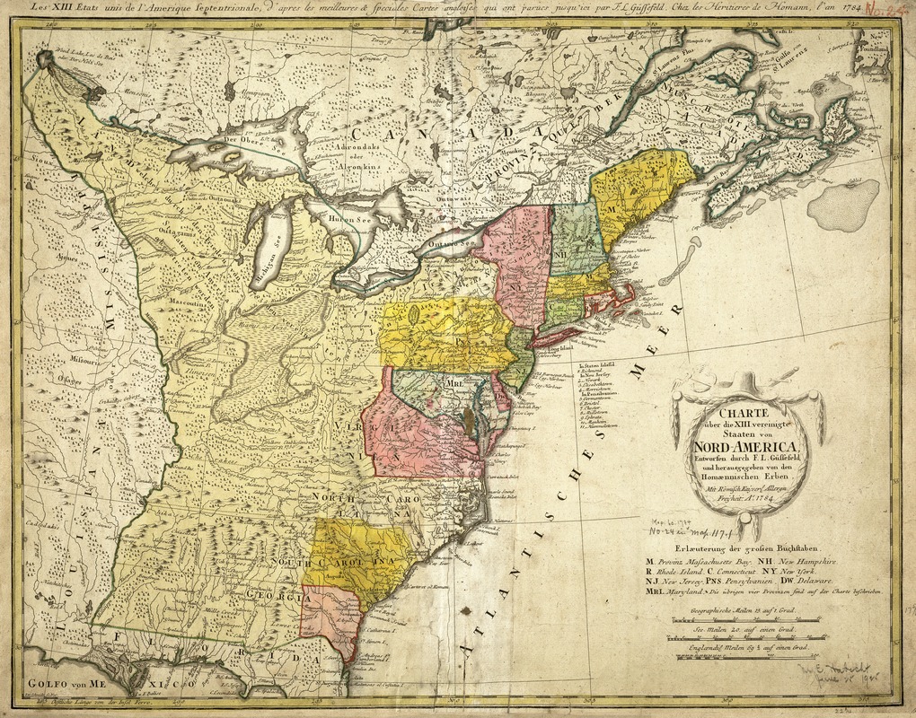
- Charte über die XIII Vereinigte Staaten von Nord-America
- Title (alt.):
-
Les XIII Etats Unis de l'Amerique septentrionale, d'apress les meilleurs & speciales cartes angloises qui ont parues jusqu'ici
- Description:
-
Following the American Revolution, European map makers were quick to publish maps recognizing the independence of the new country known as the United States. One example is this map, which was prepared by the German cartographer Franz Ludwig Güssefeld for inclusion in atlases published by the German firm Homann Heirs. The map clearly focuses on showing the extent of the new nation from the Atlantic Coast west to the Mississippi River, and north to the Great Lakes, but excluding the Spanish territories of Florida and Louisiana. However, the boundaries of the individual states were crudely drawn, with obvious mistakes made in delineating New Hampshire, Maryland, and Virginia. It is likely that the map was drawn to encourage German migration to the Americas since there is a list off the coast of the Middle Atlantic states which indicates towns in New York, New Jersey, and Pennsylvania with significant German populations.
- Creator:
- Güssefeld, F. L. (Franz Ludwig), 1744-1807
- Name on Item:
-
entworfen durch F. L. Güssefeld und hrsg. von den Homænnischen Erben.
- Date:
-
1784
- Format:
-
Maps/Atlases
- Location:
-
Boston Public Library
Norman B. Leventhal Map & Education Center - Collection (local):
-
Norman B. Leventhal Map & Education Center Collection
- Subjects:
-
United States--Maps--Early works to 1800
Atlantic Coast (U.S.)--Maps--Early works to 1800
- Places:
-
United States
- Extent:
- 1 map : hand col. ; 47 x 61 cm.
- Terms of Use:
-
No known copyright restrictions.
No known restrictions on use.
- Publisher:
-
Norimbergæ :
[Homann Heirs]
- Scale:
-
Scale [ca. 1:5,400,000].
- Language:
-
German
French
- Notes:
-
Title in margin: Les XIII Etats Unis de l'Amerique septentrionale, d'apress les meilleurs & speciales cartes angloises qui ont parues jusqu'ici.
Relief shown pictorially.
Prime meridian: Ferro.
Hand colored.
Featured in the Faces & Places Exhibit, Kravis Center, Palm Beach, FL, since 2005. MB (BRL)
- Identifier:
-
05_04_000100
- Call #:
-
G3700 1784 .G8
- Barcode:
-
39999052507983


