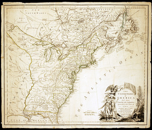
A general map of the middle British colonies, in America : viz Virginia, Màriland, Dèlaware, Pensilvania, New-Jersey, New-York, Connecticut, and Rhode Island : of Aquanishuonîgy, the country of the Confederate Indians ; comprehending Aquanishounigy proper, their place of residence, Ohio and Tiuuxsoxruntie, their deer-hunting countries, Couxsaxràge and Skaniadarâde, their beaver-hunting countries ; of the lakes Erie, Ontário and Champlain, and part of New-France: wherein is shewn the antient [sic] and present seats of the Indian nations

This map is also available in American Revolutionary Geographies Online (ARGO), a collections portal especially built for material relating to the American Revolutionary War Era. Visit ARGO to learn more about this item and explore the historical geography of North America in the late eighteenth century.
Item Information
- Title:
- A general map of the middle British colonies, in America : viz Virginia, Màriland, Dèlaware, Pensilvania, New-Jersey, New-York, Connecticut, and Rhode Island : of Aquanishuonîgy, the country of the Confederate Indians ; comprehending Aquanishounigy proper, their place of residence, Ohio and Tiuuxsoxruntie, their deer-hunting countries, Couxsaxràge and Skaniadarâde, their beaver-hunting countries ; of the lakes Erie, Ontário and Champlain, and part of New-France: wherein is shewn the antient [sic] and present seats of the Indian nations
- Cartographer:
- Evans, Lewis, 1700?-1756
- Engraver:
- Turner, James, -1759
- Dedicatee:
- Pownall, Thomas, 1722-1805
- Name on Item:
-
by Lewis Evans ; engraved by Jas. Turner in Philadelphia
- Date:
-
1755
- Format:
-
Maps/Atlases
- Location:
- New-York Historical Society
- Collection (local):
-
New-York Historical Society Collection
- Subjects:
-
United States--Maps--Early works to 1800
Canada, Eastern--Maps--Early works to 1800
Northeastern States--Maps--Early works to 1800
- Places:
-
Northeastern United States (area)
Canada
- Extent:
- 1 map : engraving ; 50 x 67 cm, on sheet 52 x 69 cm
- Terms of Use:
-
No known copyright restrictions.
No known restrictions on use.
- Publisher:
-
[London] :
Published according to act of Parliament, by Lewis Evans, June 23, 1755, and sold by R. Dodley, in Pall-Mall, London, & by the author in Philadelphia
- Scale:
-
Scale [ca. 1:2,250,000]
- Language:
-
English
- Catalog Record:
-
https://library.nyu.edu/persistent/lcn/nyu_aleph004329531?institution=NYU&persistent
- Notes:
-
Prime meridian: London and Philadelphia.
Relief shown by hachures.
From Evans, L. Geographical, historical, political, philosophical and mechanical essays, Philadelphia, 1755.
Inset: A sketch of the remaining part of Ohio R. &c.
"To the honourable Thomas Pownall Esqr. Permit me, Sir, to pay you this tribute of gratitude. for the great assistance you have given me in this map ... Your most obedient, and most humble servant, Evans."
"Explanation to the italic capitals."
"The Confederates, July 19, 1701, at Albany, surrendered this their beaver-hunting country to the English ..."
"The Confederates, formerly of 5, now of 7 Nations, called by the French Iroquois, consist of 1 Caniigaes or Mohocks, 2 Onoyuts, 3 Onondagaes, 4 Cayugaes, 5 Chemandoanes or Senecas, 6 Tuscaroras, 7 Sisisogaes."
- Identifier:
-
93225d_MiddleBritColonies1755_M31_2_30