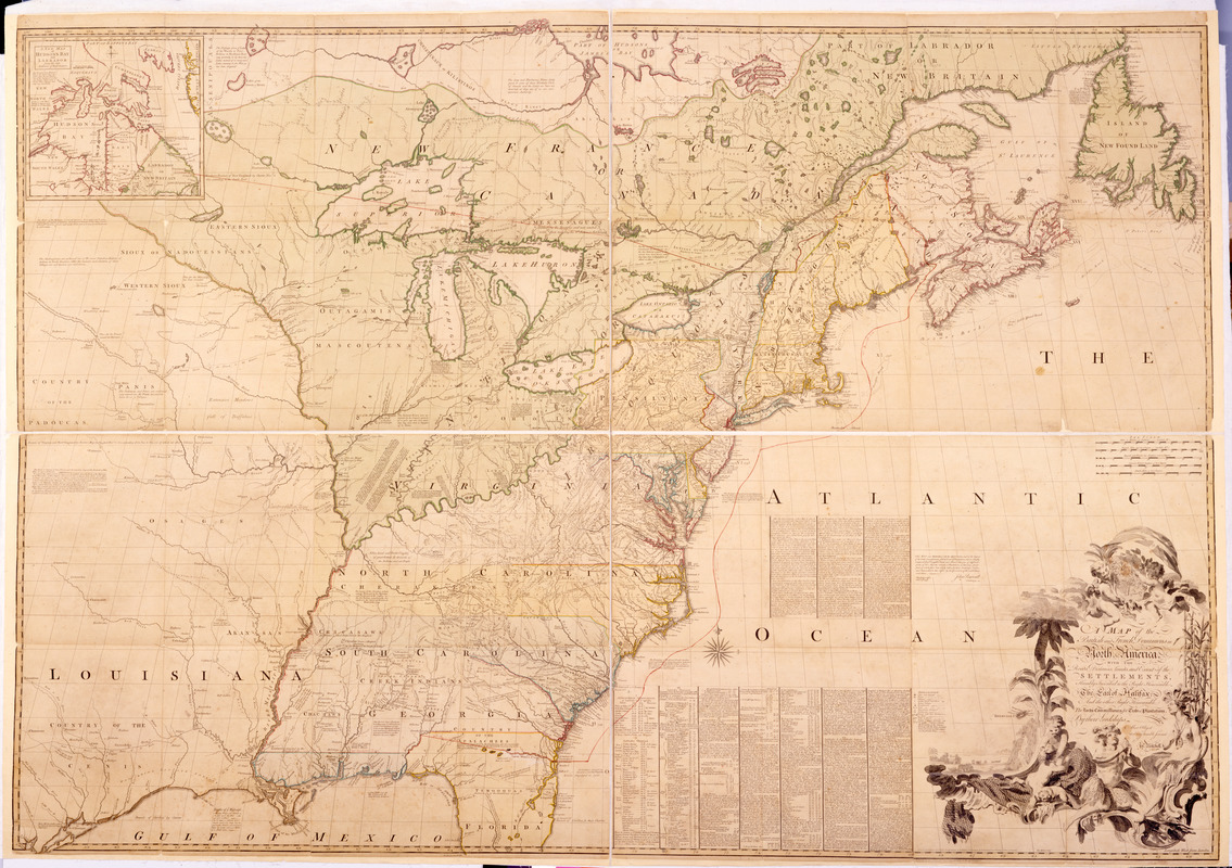
A map of the British and French dominions in North America : with the roads, distances, limits, and extent of the settlements, humbly inscribed to the Right Honourable the Earl of Halifax, and the other Right Honourable the Lords Commissioners for Trade & Plantations
This map is also available in American Revolutionary Geographies Online (ARGO), a collections portal especially built for material relating to the American Revolutionary War Era. Visit ARGO to learn more about this item and explore the historical geography of North America in the late eighteenth century.
Item Information
- Title:
- A map of the British and French dominions in North America : with the roads, distances, limits, and extent of the settlements, humbly inscribed to the Right Honourable the Earl of Halifax, and the other Right Honourable the Lords Commissioners for Trade & Plantations
- Cartographer:
- Mitchell, John, 1711-1768
- Engraver:
- Kitchin, Thomas, 1719-1784
- Bookseller:
- Millar, Andrew, 1705-1768
- Name on Item:
-
by their Lordships most obliged and very humble servant, Jno. Mitchell. Tho: Kitchin, sculp.
- Date:
-
[1755]
- Format:
-
Maps/Atlases
- Location:
- New-York Historical Society
- Collection (local):
-
New-York Historical Society Collection
- Subjects:
-
Indians of North America--Maps--Early works to 1800
United States--Maps--Early works to 1800
Canada--Maps--Early works to 1800
North America--Maps--Early works to 1800
France--Colonies--North America--Maps--Early works to 1800
England--Colonies--North America--Maps--Early works to 1800
- Places:
-
United States
North America (area)
Canada
- Extent:
- 1 map on 8 sheets : col., joined ; 135 x 191 cm, on sheets 72 x 51 cm
- Terms of Use:
-
No known copyright restrictions.
No known restrictions on use.
- Publisher:
-
[London] :
Publish'd by the Author Febry. 13th. 1755 according to Act of Parliament, and sold by And. Miller [sic], opposite Katherine [sic] Street in the Strand
- Scale:
-
Scale [ca. 1:2 000 000]
- Language:
-
English
- Catalog Record:
-
https://library.nyu.edu/persistent/lcn/nyu_aleph004281900?institution=NYU&persistent
- Notes:
-
Relief shown pictorially.
Dedication: Humbly inscribed to the Right Honourable the Earl of Halifax and the other Right Honourable the Lords Commissioners for Trade & Plantations.
First impression of 1st ed.--Kershaw.
Cartouche includes sketch of small port, and symbols of economic activity such as fishing nets, beaver, corn.
Inset: A New map of Hudson's Bay and Labrador from the late surveys of those coasts.
Shows forts, fortifications, and Indian towns and forts.
Prime meridian: London.
- Notes (date):
-
This date is inferred.
- Notes (citation):
-
LC Maps of North America, 1750-1789, 37
Holmden, H.R. Catalogue of maps, plans and charts, 267
Kershaw, K.A. Early printed maps of Canada, 349
- Identifier:
-
78539_MitchellMapOfNorthAmerica


