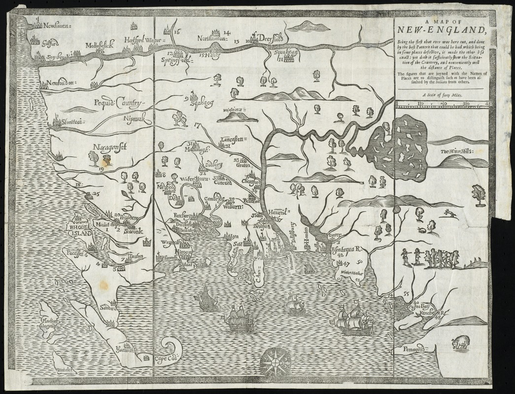
A map of New-England, being the first that ever was here cut, and done by the best pattern that could be had, which being in some places defective, it made the other less exact; yet does it sufficiently shew the scituation of the country, and conveniently well the distance of places
Item Information
- Title:
- A map of New-England, being the first that ever was here cut, and done by the best pattern that could be had, which being in some places defective, it made the other less exact; yet does it sufficiently shew the scituation of the country, and conveniently well the distance of places
- Description:
-
Based on a 1665 survey by William Reed, this is the earliest map drawn, engraved and printed in North America. The survey was commissioned by the government of Massachusetts to justify the colony's northern and southern boundaries, which are indicated by two parallel lines on the map. The map was prepared as a woodcut illustration for William Hubbard's account of the terrible Indian massacres of 1675, known as King Phillip's War, which was published simultaneously in Boston and London. The latter edition included the same map (displayed here), except the White Hills were mislabeled as the Wine Hills.
- Creator:
- Foster, John, 1648-1681
- Contributor:
- Hubbard, William, 1621 or 1622-1704
- Date:
-
[1677]
- Format:
-
Maps/Atlases
- Location:
- Phillips Academy
- Collection (local):
-
Sidney R. Knafel Map Collection at Phillips Academy, Andover MA
- Subjects:
-
New England--Maps--Early works to 1800
- Places:
-
New England (area)
- Extent:
- 1 map ; 30 x 39 cm.
- Terms of Use:
-
Rights status not evaluated.
Contact host institution for more information.
- Publisher:
-
[London] :
[s.n.]
- Scale:
-
Scale [ca. 1:900,000]
- Language:
-
English
- Notes:
-
Oriented with north to the right.
Relief shown pictorially.
"The figures that are joyned with the names of places are to distinguish such as have been assaulted by the Indians from others."
Appears in William Hubbard's A narrative of the troubles with the Indians in New England. London. 1677.
- Notes (date):
-
This date is inferred.
- Notes (citation):
-
Suarez, T. Shedding the veil, 47
McCorkle, Barbara B. New England in Early Printed Maps, 677.3
- Identifier:
-
1331


