Toggle navigation
LMEC Home
Exhibitions
Georeferencing
Tools for Teachers
Collections
My Favorites
Sign Up / Log In
Search
Search the map portal
Map Collection
Map Collection
Map Sets
Search
Search
Search for
Search In
All Fields
Creator
Title
Subject
Place
Search All Digital Collections
Advanced Search
13385 Results
Filter your Search
Place
North and Central America
9,353
United States
7,286
Suffolk (county)
1,664
Boston
1,621
Europe
1,035
Canada
949
Massachusetts
875
New York
534
more
Place
»
Topic
Boston (Mass.)--Maps
741
City planning--Massachusetts--Boston--Maps
418
United States--History--Revolution, 1775-1783--Maps
329
United States--Maps
315
Urban renewal--Massachusetts--Boston--Maps
254
Real property--Massachusetts--Boston--Maps
252
Massachusetts--Maps
219
Insurance surveys
197
more
Topic
»
Date
Date range begin
–
Date range end
Current results range from
1482
to
2023
View distribution
Creator
United States. Hydrographic Office
595
Boston Redevelopment Authority
403
Des Barres, Joseph F. W. (Joseph Frederick Wallet), 1722-1824
247
Royal United Services Institute for Defence and Security Studies
160
Jefferys, Thomas, -1771
154
George, III, King of Great Britain, 1738-1820
152
George, IV, King of Great Britain, 1762-1830
151
O.H. Bailey & Co
148
more
Creator
»
Format
Maps/Atlases
13,205
Manuscripts
985
Prints
102
Books
49
Drawings/Illustrations
44
Photographs
15
Objects/Artifacts
13
Documents
7
more
Format
»
Georeferenced
Yes
979
No
12,406
Collection
Norman B. Leventhal Map Center Collection
8,891
American Revolutionary War-Era Maps
3,305
Boston and New England Maps
2,804
Urban Maps
2,397
Maritime Charts and Atlases
1,150
William L. Clements Library Collection
910
Library of Congress Collection
618
Boston Redevelopment Authority Collection
475
more
Collection
»
Available to use
No known restrictions
9,952
Creative Commons license
1,677
Search Constraints
Sort by title
relevance
title
date (asc)
date (desc)
Number of results to display per page
100 per page
10
per page
20
per page
50
per page
100
per page
View results as:
grid view
map view
Search Results
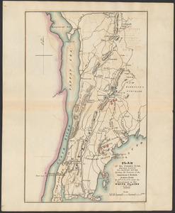
9701.
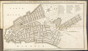
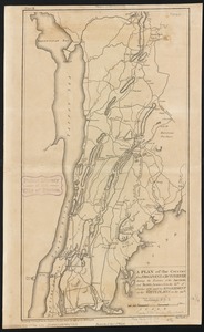
A plan of the City of New York from an actual survey anno domini MDCCLV
9702.
Plan of the city of New York in North America : surveyed in the years 1766 & 1767
9703.
PLAN of the CITY of NEW YORK, in North America : Surveyed in the Years 1766 & 1767
9704.
Plan of the city of New York in North America : surveyed in the years 1766 & 1767
9705.
Plan of the city of New-York
9706.
A plan of the city of New-York
9707.
A plan of the city of New-York & its environs to Greenwich, on the North or Hudsons River, and to Crown Point, on the East or...
9708.
A plan of the city of New-York & its environs to Greenwich, on the North or Hudsons River, and to Crown Point, on the East or...
9709.
A plan of the city of New-York, reduced from an actual survey
9710.
Plan of the city of Norwich, New London County, Connt
9711.
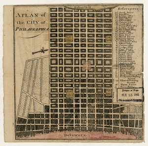
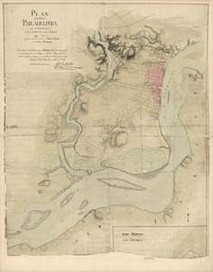
A plan of the city of Philadelphia
9712.
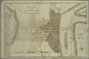
Plan of the city of Philadelphia
9713.
Plan of the city of Philadelphia
9714.
Plan of the city of Philadelphia and its environs shewing its defences during the years 1777 & 1778 : together with the siege...
9715.
A plan of the city of Philadelphia, the capital of Pennsylvania, from an actual survey
9716.
A plan of the city of Philadelphia, the capital of Pennsylvania, from an actual survey
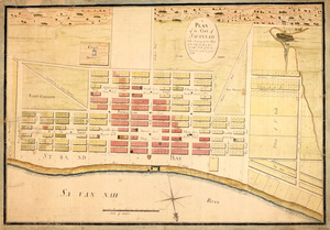
9717.
Plan of the city of Providence
9718.
Plan of the city of Quebec
9719.
Plan of the city of Quebec : shewing the portions destroyed by the two great fires, May 28th & June 28th, 1845
9720.
A Plan of the city of Quebec the capital of Canada. : As it surrendered 18 Septembr. 1759 to the British Fleet and Army,...
9721.
Plan of the city of San Domingo
9722.
A plan of the city of Savannah : with a drawing of the part of the city burnt in the dreadful fires of the 26 November & 6...
9723.
Plan of the city of St. Louis
9724.
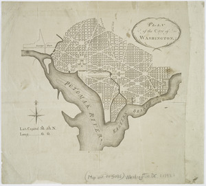
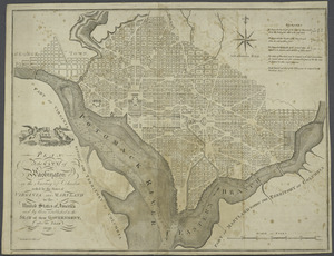
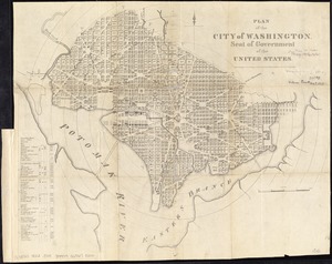
Plan of the city of Washington
9725.
Plan of the city of Washington : now building for the metropolis of America, and established as the permanent residence of...
9726.
Plan of the city of Washington
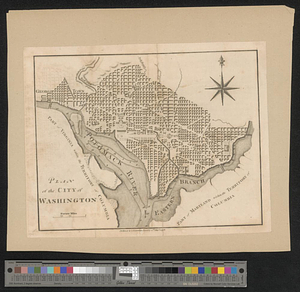
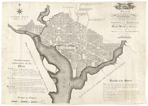
9727.
Plan of the city of Washington in the territory of Columbia : ceded by the states of Virginia and Maryland to the United States...
9728.
Plan of the city of Washington, in the territory of Columbia, ceded by the States of Virginia and Maryland to the United States...
9729.
Plan of the city of Washington in the territory of Columbia, ceded by the states of Virginia and Maryland to the United States...
9730.
Plan of the city of Washington in the territory of Columbia, ceded by the states of Virginia and Maryland to the United States...
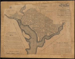
9731.
Plan of the city of Washington; now building for the metropolis of America, and established as the permanent residence of...
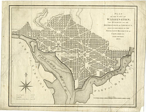
9732.
Plan of the city of Washington, seat of government of the United States
9733.
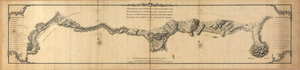
A plan of the coast of Gabarus Bay from the west end of Kennington Cove to White Point shewing the several batteries and...
9734.
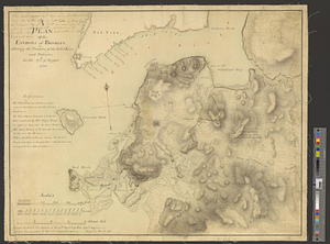
A plan of the coast of Newfoundland from Cape Bonavista to Cape Chapeau Rouge wherein seven-eights of the fishery of the island...
9735.
Plan of the Coffin Estate, corner of Summer and Chauncy Streets : to be sold by public auction on Wednesday April 26th 1856 at...
9736.
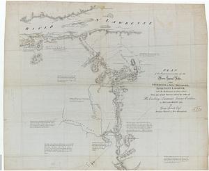
Plan of the communication from Fort Cumberland to Presqu'Isle
9737.
PLAN of the COMMUNICATION from TOWNSHIP No 8 to CATARAQUI as Surveyed by M.r Louis Kott Dep.t Prov.l Surv
9738.
Plan of the communications by the River Saint John, from Fredericton in New Brunswick to the River Saint Lawrence : with the...
9739.
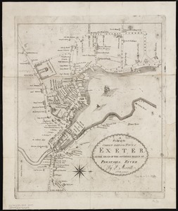
A plan of the compact part of the town of Exeter, at the head of the southerly branch of Piscataqua River
9740.
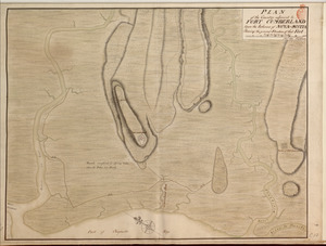
PLAN of the Country adjacent to FORT CUMBERLAND Upon the Isthmus of NOVA-SCOTIA Showing the general Situation of that Fort
9741.
Plan of the country at and in the vicinity of Forts Lee and Independency, showing the position of the British Army
9742.
PLAN of the COUNTRY from FORT EDWARD to CROWN POINT
9743.
Plan of the country from Frogs Point to Croton River shewing the positions of the American & British armies from the 12th of...
9744.
A plan of the country from Frogspoint to Croton River shewing the positions of the American and British armies from the 12th of...
9745.
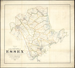
Plan of the county of Essex : compiled from the original furnished by the state and corrected under the direction of James...
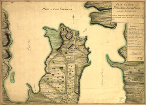
9746.
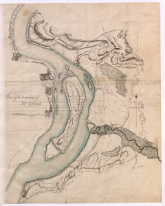
[Plan of the cove between Savin Hill and Commercial Point, Dorchester]
9747.
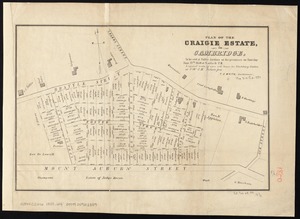
Plan of the Craigie Estate in Cambridge : to be sold at public auction on the premises on Thursday June 27th, 1850 at 4 o'clock...
9748.
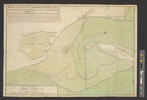
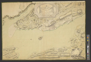
Plan of the decent [sic] and action of the 29th Decr. 1778, near the town of Savannah; by his majestys forces, under the...
9749.
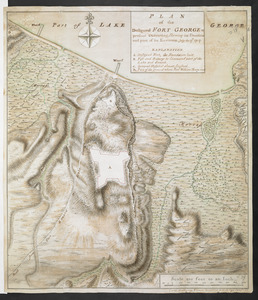
PLAN of the Designed FORT GEORGE at present executing, Shewing its situation and part of its Environs. July the 17.th 1759
9750.
Plan of the Dighton and Somerset rail road
9751.
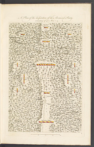
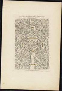
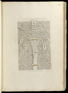
A plan of the disposition of the advanced party, consisting of 400 men
9752.
A plan of the disposition of the advanced party consisting of 400 men : to defend the workers in making the road
9753.
A plan of the disposition of the advanced party consisting of 400 men : to defend the workers in making the road
9754.
Plan of the district of Gaspé
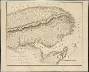
9755.
A plan of the division line between the provinces of New-York and Quebec : In the 45th degree of north latitude. Survey'd in...
9756.
Plan of the East and West India Docks, 15th April 1841
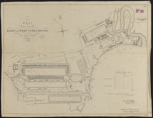
9757.
A plan of the east part of Long Island Sound : from remarks made on board His Majesty's ship the Lark, A.D. 1777
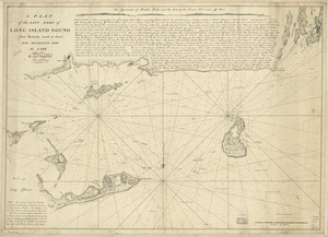
9758.
PLAN of the Encampement at Lake George the 27th Iuin 1759
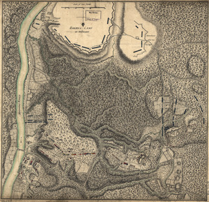
9759.
Plan of the encampment and position of the army under His Excelly. Lt. General Burgoyne : at Bræmus Heights on Hudson's River...
9760.
Plan of the encampment and position of the army under His Excelly. Lt. General Burgoyne : at Swords House on Hudson's River on...
9761.
Plan of the encampment and position of the army under His Excelly. Lt. General Burgoyne at Bræmus Heights on Hudson's River...
9762.
Plan of the encampment and position of the army under His Excelly. Lt. General Burgoyne at Swords House on Hudson's River near...
9763.
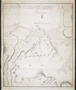
Plan of the encampment, intrenchment with theier [sic] environs at Lake George
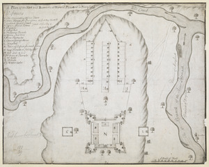
9764.
PLAN of the Encampment Intrenchment with thier Environs at LAKE GEORGE
9765.
PLAN OF THE ENCAMPMENT OF THE ARMY AT LAKE GEORGE JUNE 1759
9766.
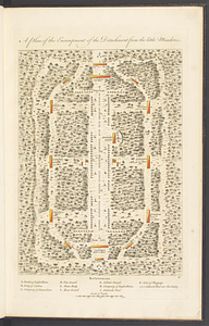
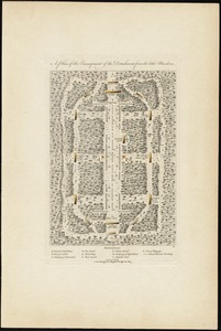
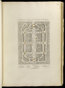
A plan of the encampment of the detachment from the Little Meadows
9767.
A plan of the encampment of the detachment from the little Meadows
9768.
A plan of the encampment of the detachment from the little Meadows
9769.
A plan of the entervale [sic] and hundred acre lotts in the township of Piermont
9770.
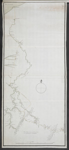
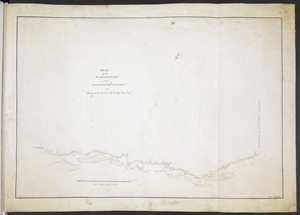
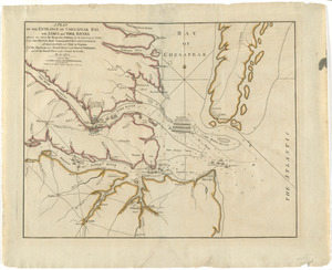
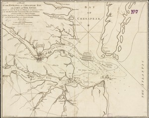
A plan of the entrance of Chesapeak Bay, with James and York Rivers : wherein are shown the respective positions (in the...
9771.
A plan of the entrance of Chesapeak Bay, with James and York rivers : wherein are shewn the respective positions (in the...
9772.
A plan of the entrance of Chesapeak Bay, with James and York rivers : wherein are shewn the respective positions (in the...
9773.
A Plan of the entrance of Chesapeak [sic] Bay, with James and York Rivers : wherein are shewn the respective positions (in the...
9774.
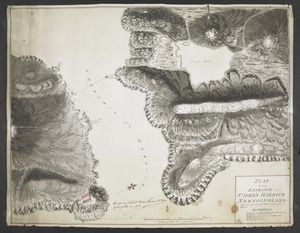
PLAN OF THE ENTRANCE OF ST IOHN'S HARBOUR NEWFOUNDLAND Shewing the additional Work's erecting for its defence
9775.
Plan of the entrance of the Harbour of Pensacola shewing the situation of the new battery's laid out and begun building in...
9776.
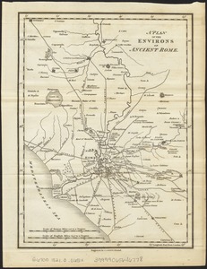
A plan of the environs of ancient Rome
9777.
A plan of the environs of Brooklyn showing the position of the rebel lines and defences on the 27th of August 1776
9778.
Plan of the Environs of Fort Edward
9779.
Plan of the environs of Halifax in Nova Scotia with the temporary works constructed for the protection of the town, and His...
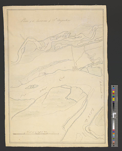
9780.
Plan of the environs of St. Augustine
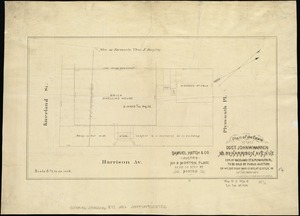
9781.
Plan of the estate of late Doct. John W. Warren, No. 89 Harrison Avenue, cor. of Kneeland St. & Plymouth Pl. to be sold at...
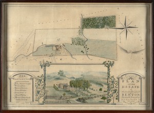
9782.
Plan of the estate of Stephen R. and Charles F. Benton, Richmond Township, Berkshire Co., state of Massachusetts
9783.
Plan of the estate of the late Joseph Head Esq. to be sold at auction, Oct. 8th 1841
9784.
Plan of the estate of the late Richd. F. Ha[nn]on, Esq., Petersburg, Va. (northern portion, in lots)
9785.
Plan of the estate of the late Warren White : to be sold at public auction on Wednesday March 27th 1872 at 12 o'clock m. on the...
9786.
Plan of the estate on the southerly corner of Washington and Franklin Streets : to be sold by public auction on Saturday June...
9787.
Plan of the estates nos. 246 to 252 Congress corner of Purchase Street and nos. 59 to 69 Purchase Street : to be sold by public...
9788.
Plan of the estates of Admiral Sr. Jas. Douglas bart. called Douglas & Ravenscroft, and the estate of Robert Harvey esqr....
9789.
Plan of the Federal St. Meeting House estate : to be sold by public auction, on Thursday February 24th 1859, at 12 o'clock noon...
9790.
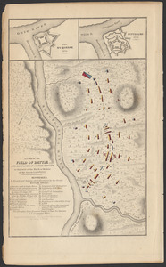
A plan of the field of battle and disposition of the troops as they were on the march at the time of the attack, July 9th, 1755
9791.
A plan of the field of battle and disposition of the troops, as they were on the march at the time of the attack on the 9th of...
9792.
A plan of the field of battle and disposition of the troops, as they were on the march at the time of the attack on the 9th of...
9793.
A plan of the field of battle and disposition of the troops, as they were on the march at the time of the attack on the 9th of...
9794.
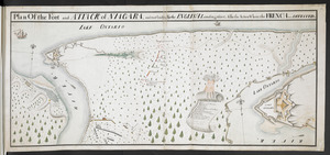
Plan Of the Fort and ATTACK of NIAGARA, and road leading To the ENGLISH Landing place, Also the Action Where the FRENCH were...
9795.
A Plan of the Fort and Barracks at Mount Pleasant in Maryland
9796.
Plan of the fort and fortress at Crown Point with their environs : With the disposition of the English Army under the command...
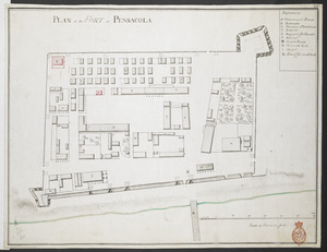
9797.
PLAN of the FORT at PENSACOLA
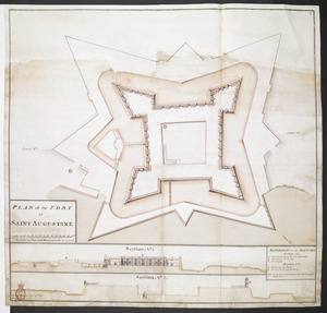
9798.
PLAN of the FORT at SAINT AUGUSTINE
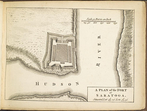
9799.
A plan of the fort at Saratoga : situated lat. 43 20' lon. 73 30'
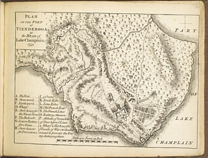
9800.
Plan of the fort at Tienderoga at the head of Lake Champlain, 1758
‹ Prev
Next ›
1
2
…
94
95
96
97
98
99
100
101
102
…
133
134


![A plan of the city of New-York & its environs to Greenwich, on the North or Hudsons River, and to Crown Point, on the East or Sound River, shewing the several streets, publick buildings, docks, fort & battery, with the true form & course of the commanding grounds, with and without the town : survey'd in the winter, 1775 [i.e. 1766]](https://bpldcassets.blob.core.windows.net/derivatives/images/commonwealth:z603vs09b/image_thumbnail_300.jpg)
![A plan of the city of New-York & its environs to Greenwich, on the North or Hudsons River, and to Crown Point, on the East or Sound River, shewing the several streets, publick buildings, docks, fort & battery, with the true form & course of the commanding grounds, with and without the town : survey'd in the winter, 1775 [i.e. 1766]](https://bpldcassets.blob.core.windows.net/derivatives/images/commonwealth:6t053q479/image_thumbnail_300.jpg)


![A plan of the coast of Newfoundland from Cape Bonavista to Cape Chapeau Rouge wherein seven-eights of the fishery of the island is caried [sic] on](https://bpldcassets.blob.core.windows.net/derivatives/metadata/commonwealth-oai:cz30tq534/image_thumbnail_300.jpg)


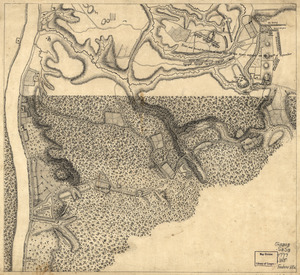
![[Plan of the cove between Savin Hill and Commercial Point, Dorchester]](https://bpldcassets.blob.core.windows.net/derivatives/images/commonwealth:js956k66d/image_thumbnail_300.jpg)
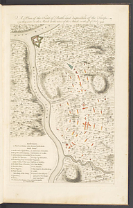
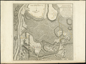
![Plan of the decent [sic] and action of the 29th Decr. 1778, near the town of Savannah; by his majestys forces, under the command of Lt. Colol. Campbell of the 71st Regt. foot](https://bpldcassets.blob.core.windows.net/derivatives/metadata/commonwealth-oai:qj72t576b/image_thumbnail_300.jpg)


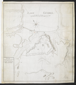
![Plan of the encampment, intrenchment with theier [sic] environs at Lake George](https://bpldcassets.blob.core.windows.net/derivatives/metadata/commonwealth-oai:v9800134b/image_thumbnail_300.jpg)
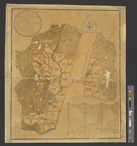
![A plan of the entervale [sic] and hundred acre lotts in the township of Piermont](https://bpldcassets.blob.core.windows.net/derivatives/metadata/commonwealth-oai:02874t092/image_thumbnail_300.jpg)

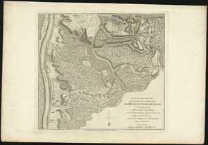
![A Plan of the entrance of Chesapeak [sic] Bay, with James and York Rivers](https://bpldcassets.blob.core.windows.net/derivatives/images/commonwealth:q524nf233/image_thumbnail_300.jpg)

![Plan of the estate of the late Richd. F. Ha[nn]on, Esq., Petersburg, Va. (northern portion, in lots)](https://bpldcassets.blob.core.windows.net/derivatives/images/commonwealth:w9505s204/image_thumbnail_300.jpg)