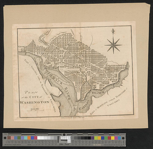
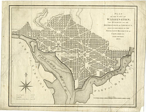
Plan of the city of Washington; now building for the metropolis of America, and established as the permanent residence of Congress after the year 1800
This map is also available in American Revolutionary Geographies Online (ARGO), a collections portal especially built for material relating to the American Revolutionary War Era. Visit ARGO to learn more about this item and explore the historical geography of North America in the late eighteenth century.
Item Information
- Title:
- Plan of the city of Washington; now building for the metropolis of America, and established as the permanent residence of Congress after the year 1800
- Contributor:
- Baker, B. (Benjamin), active 1766-1824
- Creator:
- Ellicott, Andrew, 1754-1820
- Date:
-
1793
- Format:
-
Maps/Atlases
- Genre:
-
Cartouches (Graphic)
- Location:
- William L. Clements Library
- Collection (local):
-
William L. Clements Library Collection
- Subjects:
-
Washington (D.C.)--Maps
- Places:
-
District of Columbia
- Extent:
- 1 map ; 27.7 x 35 cm.
- Terms of Use:
-
The University of Michigan Library provides access to these materials for educational and research purposes. These materials may be under copyright. If you decide to use any of these materials, you are responsible for making your own legal assessment and securing any necessary permission. If you have questions about the collection, please contact the William L. Clements Library.
Contact host institution for more information.
- Publisher:
-
[London] :
W. Brent
- Scale:
-
Scale 1:34,000.
- Language:
-
English
- Catalog Record:
-
Catalog record
- Notes:
-
Engraved by: B. Baker, Islington.
- Identifier:
-
952
- Barcode:
-
B3001007