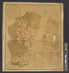
Plan of the estates of Admiral Sr. Jas. Douglas bart. called Douglas & Ravenscroft, and the estate of Robert Harvey esqr. situated in Old Road Division and Parish of St. Mary in Antigua : surveyed in 1787
This map is also available in American Revolutionary Geographies Online (ARGO), a collections portal especially built for material relating to the American Revolutionary War Era. Visit ARGO to learn more about this item and explore the historical geography of North America in the late eighteenth century.
Item Information
- Title:
- Plan of the estates of Admiral Sr. Jas. Douglas bart. called Douglas & Ravenscroft, and the estate of Robert Harvey esqr. situated in Old Road Division and Parish of St. Mary in Antigua : surveyed in 1787
- Creator:
- Killian, John
- Name on Item:
-
by John Killian surveyor general
- Date:
-
1787
- Format:
-
Maps/Atlases
- Genre:
-
Manuscript maps
- Location:
- William L. Clements Library
- Collection (local):
-
William L. Clements Library Collection
- Subjects:
-
Real property--Antigua and Barbuda--Antigua--Maps
Antigua--Maps
Douglas, James, Sir, 1703-1787
Harvey, Robert, 1733-1791
Brook, John
- Places:
-
Antigua and BarbudaAntigua (island)
- Extent:
- 1 ms. map : col. ; 53.5 x 45 cm
- Terms of Use:
-
The University of Michigan Library provides access to these materials for educational and research purposes. These materials may be under copyright. If you decide to use any of these materials, you are responsible for making your own legal assessment and securing any necessary permission. If you have questions about the collection, please contact the William L. Clements Library.
Contact host institution for more information.
- Scale:
-
Scale ca. 1:5,544.
- Language:
-
English
- Catalog Record:
-
Catalog record
- Notes:
-
Gives acreage of 36 plots in the named estates, identifies related lands, and shows houses and roads.
- Identifier:
-
8694
- Barcode:
-
B1937102