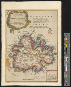
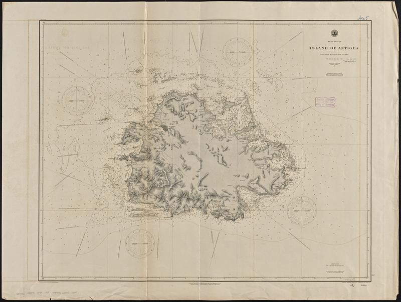
West Indies, Island of Antigua : from British surveys in 1848 and 1863
Item Information
- Title:
- West Indies, Island of Antigua : from British surveys in 1848 and 1863
- Issuing body:
- United States. Hydrographic Office
- Engraver:
- Enthoffer, E. J. (Edward J.)
- Engraver:
- Hazzard, J. L. (John L.)
- Draftsman:
- Pohlers, G. F. (George F.)
- Name on Item:
-
drawn by G.F. Pohlers ; engraved by E.J. Enthoffer and J.L. Hazzard
- Date:
-
1889
- Format:
-
Maps/Atlases
- Genre:
-
Nautical charts
- Location:
-
Boston Public Library
Norman B. Leventhal Map & Education Center - Collection (local):
-
Norman B. Leventhal Map & Education Center Collection
- Subjects:
-
Antigua--Maps
Nautical charts--Antigua and Barbuda--Antigua
- Places:
-
Antigua and BarbudaAntigua (island)
- Extent:
- 1 map : hand colored ; 71 x 91 cm
- Terms of Use:
-
No known copyright restrictions.
No known restrictions on use.
- Publisher:
-
[Washington, D.C.] :
Hydrographic Office
- Scale:
-
Scale approximately 1:49,500
- Language:
-
English
- Notes:
-
Relief shown by shading, form lines and spot heights. Depths shown by soundings and isolines.
- Identifier:
-
06_01_015642
- Call #:
-
G9096.P5 svar .U55 no. 1004
- Barcode:
-
39999085938544