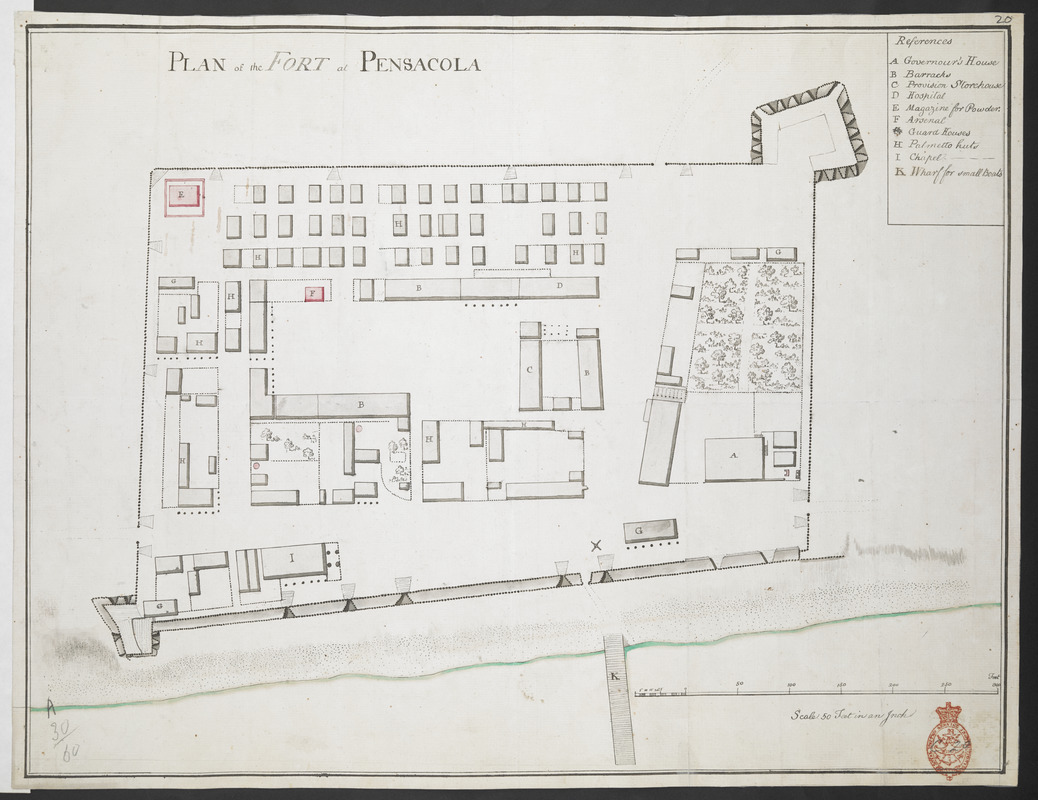
PLAN of the FORT at PENSACOLA
This map is also available in American Revolutionary Geographies Online (ARGO), a collections portal especially built for material relating to the American Revolutionary War Era. Visit ARGO to learn more about this item and explore the historical geography of North America in the late eighteenth century.
Item Information
- Title:
- PLAN of the FORT at PENSACOLA
- Former owner:
- Amherst, Jeffery Amherst, Baron, 1717-1797
- Former owner:
- Royal United Services Institute for Defence and Security Studies
- Date:
-
[1763?–1767?]
- Format:
-
Maps/Atlases
- Location:
- British Library
- Collection (local):
-
British Library Collection
- Subjects:
-
Fortification--Florida--Pensacola--Maps, Manuscript--Early works to 1800
Military art and science--Florida--Pensacola--Maps, Manuscript--Early works to 1800
Pensacola (Fla.)--Maps, Manuscript--Early works to 1800
- Places:
-
Escambia (county)Pensacola
- Extent:
- 1 map : manuscript pen and ink, in red and black ; 36 x 48 cm
- Terms of Use:
-
No known copyright restrictions.
This work is licensed for use under a Creative Commons Attribution Non-Commercial Share Alike License (CC BY-NC-SA).

- Publisher:
-
[Place of production not identified] :
[Producer not identified]
- Scale:
-
Scale approximately 1:600
- Language:
-
English
- Catalog Record:
-
http://searcharchives.bl.uk/IAMS_VU2:IAMS040-001999746
- Notes:
-
Date range attributed as map shows fort before alterations and enlargement in 1767 (?).
Shows title at upper left.
Shows lettered key (A-K) at upper right.
Shows scale bar at lower right, "Scale 50 Feet in an inch".
Compare "A PLAN of the FORT at PENSACOLA" - see Maps K.Top.122.96.
Compare "Plan and Sections of the Fort at Pensacola, 1763. MS. 50 feet to 1 inch" held by The National Archives, Kew (CO 700/FLORIDA5).
Copy at Add Ms 57,714.20. Bound in R.U.S.I. Vol LXXIX. Shows red stamp of R.U.S.I. at lower right. Shows manuscript addition of "20" in pencil at upper right. Shows manuscript annotations in pencile of "C 20" at lower right and "A 30/60" at lower left. Laid on archival tissue. Green circular label to verso shows "37". White label to verso shows "DRAWER 30 SECTION 1". Blue label to verso showsn "A 30/60".
- Notes (date):
-
9999