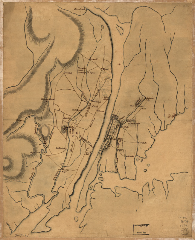
Plan of the country at and in the vicinity of Forts Lee and Independency, showing the position of the British Army
This map is also available in American Revolutionary Geographies Online (ARGO), a collections portal especially built for material relating to the American Revolutionary War Era. Visit ARGO to learn more about this item and explore the historical geography of North America in the late eighteenth century.
Item Information
- Title:
- Plan of the country at and in the vicinity of Forts Lee and Independency, showing the position of the British Army
- Date:
-
[1776?]
- Format:
-
Maps/Atlases
Manuscripts
- Location:
- Library of Congress Geography and Map Division
- Collection (local):
-
Library of Congress Collection
- Subjects:
-
Bergen County (N.J.)--History--Revolution, 1775-1783--Maps, Manuscript--Early works to 1800
Bronx (New York, N.Y.)--History--Revolution, 1775-1783--Maps, Manuscript--Early works to 1800
- Places:
-
Bergen (county)
New YorkBronx
- Extent:
- 1 manuscript map : hand color; on sheet 40 x 32 cm.
- Terms of Use:
-
No known copyright restrictions.
This work is licensed for use under a Creative Commons Attribution Non-Commercial Share Alike License (CC BY-NC-SA).

- Scale:
-
Scale ca. 1:160,000
- Language:
-
English
- Catalog Record:
-
https://lccn.loc.gov/gm71002221
- Notes:
-
Title from Philip Lee Phillips' A list of maps of America.
Manuscript, pen-and-ink and watercolor.
Has watermarks.
Shows British and Hessian troop positions in eastern Bergen County, New Jersey and Bronx, New York.
- Notes (citation):
-
LC Maps of North America, 1750-1789, 1265
- Identifier:
-
ar126500


