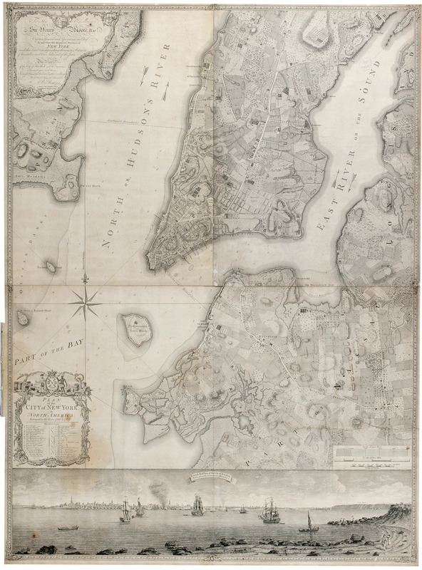
Plan of the city of New York in North America : surveyed in the years 1766 & 1767
This map is also available in American Revolutionary Geographies Online (ARGO), a collections portal especially built for material relating to the American Revolutionary War Era. Visit ARGO to learn more about this item and explore the historical geography of North America in the late eighteenth century.
Item Information
- Title:
- Plan of the city of New York in North America : surveyed in the years 1766 & 1767
- Cartographer:
- Ratzer, Bernard
- Engraver:
- Kitchin, Thomas, 1719-1784
- Name on Item:
-
B. Ratzer ; Thos. Kitchin sculpt.
- Date:
-
[ca. 1770]
- Format:
-
Maps/Atlases
- Location:
- New-York Historical Society
- Collection (local):
-
New-York Historical Society Collection
- Subjects:
-
New York (N.Y.)--Maps
New York (N.Y.)--Maps--Early works to 1800
New York (N.Y.)--Pictorial works
Buildings--New York (State)--New York--Maps
Landforms--New York (State)--New York--Maps
Rivers--New York (State)--New York--Maps
Ponds--New York (State)--New York--Maps
Wetlands--New York (State)--New York--Maps
- Places:
-
New YorkNew York
- Extent:
- 1 map on 3 sheets : assembled. Ill. ; 99 x 87 cm., 122 x 91 overall
- Terms of Use:
-
No known copyright restrictions.
No known restrictions on use.
- Scale:
-
Scale [ca. 1:9,800]
- Language:
-
English
- Catalog Record:
-
https://library.nyu.edu/persistent/lcn/nyu_aleph001748159?institution=NYU&persistent
- Notes:
-
1st state.
Covers part of modern New York City: Manhattan below the later 60th Street and Brooklyn north of the later 30th Street and west of the later Union Avenue; also a small part of modern Queens and of Jersey City, New Jersey. Shows built up and cultivated areas, streets and rural roads, some buildings, piers. Also shows streams, ponds and wetlands.
Shows relief by hachures. Shows depths by soundings.
Dedication at upper left: "To His Excellency Sir Henry Moore, Bart. Captain General and Governour in Chief, in and over His Majesty's Province of New York and the territories depending thereon in America Chancellor and Vice Admiral of the same. This plan, of the City of New York and its environs, survey'd and laid down: is most humbly dedicated by his Excellency's most obdet. humble servant, B. Ratzer Lieut. in his Majestys 60th. or Royal American Regt."
Includes key to various churches and public buildings.
Includes view A south west view of the City of New York, taken from the Governours Island at [asterick]; based on a work by Thomas Davies.
- Notes (citation):
-
Cohen, Paul E. and Robert T. Augustyn. Manhattan in Maps, p. 73-77
Stokes, I.N. Phelps. Iconography of Manhattan Island, v. 1, p. 342-343
- Identifier:
-
83586d_PlanCityNY1770_Ratzer9211_1