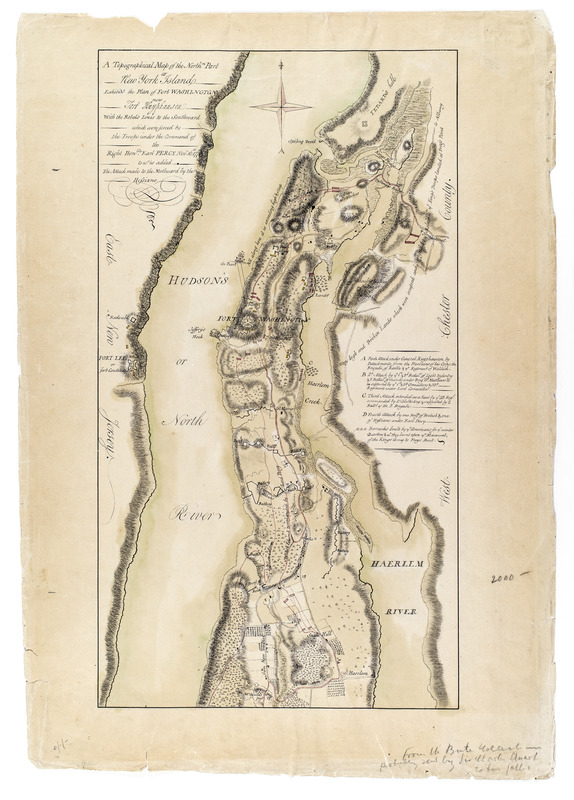
A Topographical map of the northn. part of New York Island, exhibitg. the plan of Fort Washington now Fort Knyphausen, with the rebel's lines to the southward, which were forced by the troops under the command of the Right Honble. Earl Percy Novr. 16th. 1776, to wc. is added, the attack made to the northward by the Hessians : Topographical map of the northern part of New York Island, exhibiting the plan of Fort Washington now Fort Knyphausen, with the Rebel's lines to the southward, which were forced by the troops under the command of the Right Honourable Earl Percy November 16th 1776, to which is added, the attack made to the northward by the Hessians
This map is also available in American Revolutionary Geographies Online (ARGO), a collections portal especially built for material relating to the American Revolutionary War Era. Visit ARGO to learn more about this item and explore the historical geography of North America in the late eighteenth century.
Item Information
- Title:
- A Topographical map of the northn. part of New York Island, exhibitg. the plan of Fort Washington now Fort Knyphausen, with the rebel's lines to the southward, which were forced by the troops under the command of the Right Honble. Earl Percy Novr. 16th. 1776, to wc. is added, the attack made to the northward by the Hessians : Topographical map of the northern part of New York Island, exhibiting the plan of Fort Washington now Fort Knyphausen, with the Rebel's lines to the southward, which were forced by the troops under the command of the Right Honourable Earl Percy November 16th 1776, to which is added, the attack made to the northward by the Hessians
- Date:
-
[ca. 1777]
- Format:
-
Maps/Atlases
Manuscripts
- Location:
- New-York Historical Society
- Collection (local):
-
New-York Historical Society Collection
- Subjects:
-
Harlem Heights, Battle of, N.Y., 1776--Maps
Manhattan (New York, N.Y.)--History--18th century--Battlefields--Maps
Manhattan (New York, N.Y.)--History--18th century--Naval operations--Maps
Fort Washington (New York, N.Y.)--Capture, 1776--Maps
Fort Lee (N.J.)--Maps
Inwood (New York, N.Y.)--Maps
Harlem (New York, N.Y.)--Maps
Hamilton Heights (New York, N.Y.)--Maps
Manhattanville (N.Y.)--Maps
Morningside Heights (New York, N.Y.)--Maps
Central Harlem (New York, N.Y.)--Maps
East Harlem (New York, N.Y.)--Maps
Land use, Rural--New York (State)--New York--Maps
Landowners--New York (State)--New York--Maps
Landforms--New York (State)--New York--Maps
Buildings--New York (State)--New York--Maps
Battlefields--New York (State)--New York--Maps
Wetlands--New York (State)--New York--Maps
- Places:
-
Washington Heights
Fort Washington (historical)
Fort Lee (historical)
Inwood
- Extent:
- 1 map : ms., col. ; 47 x 26 cm.
- Terms of Use:
-
No known copyright restrictions.
No known restrictions on use.
- Scale:
-
Scale not given
- Language:
-
English
- Catalog Record:
-
https://library.nyu.edu/persistent/lcn/nyu_aleph001563344?institution=NYU&persistent
- Notes:
-
Military topographical map. Covers Manhattan north of modern 105th Street and also the coast of New Jersey and the Bronx. Shows positions and movements of forces. Also shows roads, vegetation, some buildings and a few landowner names.
Shows relief by shading.
Date of situation 1776 Nov.
Date of ms. ca. 1777. This ms. appears to be a copy of Sauthier's printed map of that date--compare Maps and charts of North America and the West Indies. Washington: Library of Congress, 1981, p. 250. Also Stokes, I.N. Phelps. Iconography of Manhattan Island, v. 6, p. 355.
Pen-and-ink, watercolor and ink wash on paper.
Annotated by library on recto: "From the Bute collection probably sent by Sir Charles Stuart to his father."
Includes descriptive key.
- Identifier:
-
93224d_TopoMapNY1777_M35_5_4

 IIIF Manifest