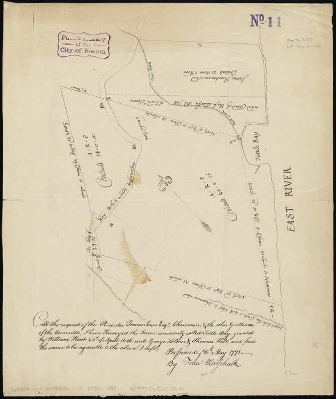
At the request of the recorder Thomas Jones Esqr. chairman, & the other gentlemen of the committee, I have surveyed the farm commonly called Tuttle Bay, granted by William Keist 23d of April 1646. unto George Holmes & Thomas Hall, and find the same to be agreeable to the above draft
Item Information
- Title:
- At the request of the recorder Thomas Jones Esqr. chairman, & the other gentlemen of the committee, I have surveyed the farm commonly called Tuttle Bay, granted by William Keist 23d of April 1646. unto George Holmes & Thomas Hall, and find the same to be agreeable to the above draft
- Title (alt.):
-
Tuttle Bay
- Creator:
- Maerschalck, Francis W., -1776
- Name on Item:
-
performed ye 16th May 1771 by Franc. Marschalk.
- Date:
-
[1880?–1889?]
- Format:
-
Maps/Atlases
- Location:
-
Boston Public Library
Norman B. Leventhal Map & Education Center - Collection (local):
-
Norman B. Leventhal Map & Education Center Collection
- Subjects:
-
Real property--New York (State)--New York--Maps
Landowners--New York (State)--New York--Maps
Rivers--New York (State)--New York--Maps
Buildings--New York (State)--New York--Maps
Midtown Manhattan (New York, N.Y.)--Maps--Early works to 1800--Facsimiles
Turtle Bay (New York, N.Y.)--Maps--Early works to 1800--Facsimiles
- Places:
-
New YorkNew YorkManhattan
- Extent:
- 1 map ; on sheet 43 x 36 cm
- Terms of Use:
-
No known copyright restrictions.
No known restrictions on use.
- Publisher:
-
S.l :
s.n.
- Scale:
-
Scale [ca. 1:3,100]
- Language:
-
English
- Notes:
-
Facsimile of a ms. map. Covers the area later bounded by 42nd and 53rd Streets, 3rd Avenue and the East River, Manhattan, New York (N.Y.) Shows property lines, acreages, buildings and owners' names. Gives some dimensions. Also shows roads and streams.
Oriented with north to the upper left.
- Identifier:
-
06_01_010769
- Call #:
-
G3804.N4:2M3G46 1771 .M34 1880
- Barcode:
-
39999065677112