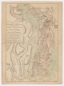
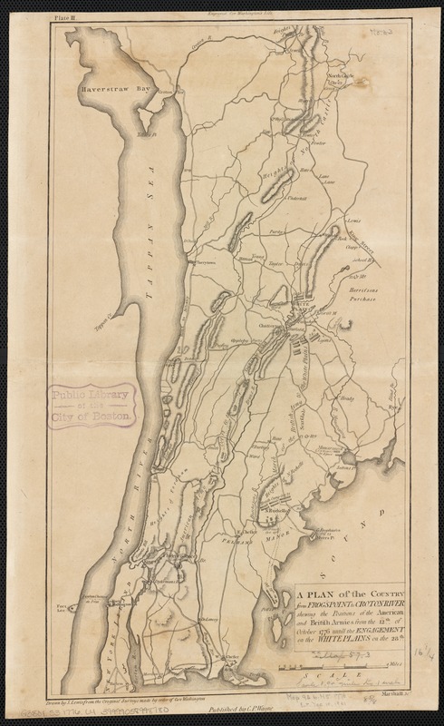
A plan of the country from Frogspoint to Croton River shewing the positions of the American and British armies from the 12th of October 1776 until the engagement on the White Plains on the 28th
This map is also available in American Revolutionary Geographies Online (ARGO), a collections portal especially built for material relating to the American Revolutionary War Era. Visit ARGO to learn more about this item and explore the historical geography of North America in the late eighteenth century.
Item Information
- Title:
- A plan of the country from Frogspoint to Croton River shewing the positions of the American and British armies from the 12th of October 1776 until the engagement on the White Plains on the 28th
- Creator:
- Lewis, Samuel, 1753 or 4-1822
- Name on Item:
-
drawn by S. Lewis from the original surveys made by order of Gen. Washington ; Marshall sct.
- Date:
-
[1776]
- Format:
-
Maps/Atlases
- Location:
-
Boston Public Library
Norman B. Leventhal Map & Education Center - Collection (local):
-
Norman B. Leventhal Map & Education Center Collection
- Subjects:
-
White Plains, Battle of, White Plains, N.Y., 1776--Maps--Early works to 1800
Fortification--New York (State)--History--Revolution, 1775-1783--Maps--Early works to 1800
New York (State)--History--Revolution, 1775-1783--Maps--Early works to 1800
- Places:
-
New YorkWestchester (county)White Plains
- Extent:
- 1 map ; 42 x 22 cm.
- Terms of Use:
-
No known copyright restrictions.
No known restrictions on use.
- Publisher:
-
[Philadelphia] :
C.P. Wayne
- Scale:
-
Scale [ca. 1:128,400]
- Language:
-
English
- Notes:
-
Relief shown by hachures.
"Engraved for Washingtons Life."
In upper left corner: "Plate III."
- Notes (date):
-
This date is inferred.
- Identifier:
-
06_01_003134
- Call #:
-
G3801.S3 1776 .L4
- Barcode:
-
39999058998780