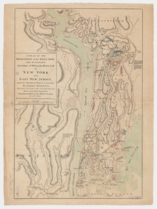
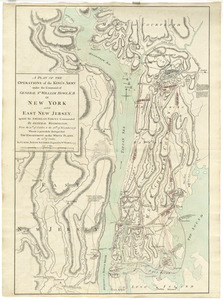
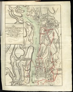
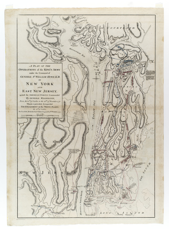
A plan of the operations of the King's army under the command of General Sr. William Howe, K.B. in New York and east New Jersey, against the American forces commanded by General Washington, from the 12th. of October, to the 28th. of November 1776 : wherein is particularly distinguished the engagement on the White Plains, the 28th. of October
This map is also available in American Revolutionary Geographies Online (ARGO), a collections portal especially built for material relating to the American Revolutionary War Era. Visit ARGO to learn more about this item and explore the historical geography of North America in the late eighteenth century.
Item Information
- Title:
- A plan of the operations of the King's army under the command of General Sr. William Howe, K.B. in New York and east New Jersey, against the American forces commanded by General Washington, from the 12th. of October, to the 28th. of November 1776 : wherein is particularly distinguished the engagement on the White Plains, the 28th. of October
- Cartographer:
- Sauthier, Claude Joseph
- Engraver:
- Faden, William, 1749-1836
- Publisher:
- Faden, William, 1749-1836
- Name on Item:
-
by Claude Joseph Sauthier ; engraved by Wm. Faden, 1777
- Date:
-
[1777]
- Format:
-
Maps/Atlases
- Location:
- New-York Historical Society
- Collection (local):
-
New-York Historical Society Collection
- Subjects:
-
Westchester County (N.Y.)--Maps--Early works to 1800
United States--History--Revolution, 1775-1783--Maps--Early works to 1800
New York (State)--History--Revolution, 1775-1783--Maps--Early works to 1800
New Jersey--History--Revolution, 1775-1783--Maps--Early works to 1800
White Plains, Battle of, White Plains, N.Y., 1776--Maps--Early works to 1800
- Places:
-
Westchester (county)White Plains
- Extent:
- 1 map : col. ; 74 x 49.8 cm on sheet 77 x 55 cm.
- Terms of Use:
-
No known copyright restrictions.
No known restrictions on use.
- Publisher:
-
[London] :
Published as Act directs, Feby. 25th 1777, by W. Faden, corner of St. Martins Lane, Charing Cross
- Scale:
-
Scale 1:90,000.
- Language:
-
English
- Catalog Record:
-
https://library.nyu.edu/persistent/lcn/nyu_aleph004267183?institution=NYU&persistent
- Notes:
-
First state without British ships off "Terry Town."
Shows movements of British and American forces prior to, during, and after the Battle of White Plains.
Many notations provide details of movements and events.
- Notes (date):
-
This date is inferred.
- Notes (citation):
-
LC Maps of North America, 1750-1789, 1055
Nebenzahl, Kenneth. A bibliography of printed battle plans..., no. 101
Stevens and Tree. Comparative cartography, 45a
- Identifier:
-
58273_PlanOperations1777_M20_3_7