Toggle navigation
LMEC Home
Exhibitions
Georeferencing
Tools for Teachers
Collections
My Favorites
Sign Up / Log In
Search
Search the map portal
Map Collection
Map Collection
Map Sets
Search
Search
Search for
Search In
All Fields
Creator
Title
Subject
Place
Search All Digital Collections
Advanced Search
82 Results
My Search
Start Over
More Like
commonwealth:p8418t43x
Remove constraint More Like: commonwealth:p8418t43x
Filter your Search
Place
United States
70
North and Central America
69
New York
22
North America
11
Canada
10
New Jersey
10
Westchester (county)
9
Boston
4
more
Place
»
Topic
United States--History--Revolution, 1775-1783--Maps--Early works to 1800
38
New Jersey--History--Revolution, 1775-1783--Maps--Early works to 1800
14
New York (State)--History--Revolution, 1775-1783--Maps--Early works to 1800
14
United States--Maps--Early works to 1800
8
White Plains, Battle of, White Plains, N.Y., 1776--Maps--Early works to 1800
7
Landforms--New York (State)--Maps
6
North America--History--Revolution, 1775-1783--Maps--Early works to 1800
6
North America--Maps--Early works to 1800
6
more
Topic
»
Date
Date range begin
–
Date range end
Current results range from
1755
to
1826
View distribution
Creator
Faden, William, 1749-1836
11
Bonne, Rigobert, 1727-1794
4
Brion de la Tour, Louis
3
Erskine, Robert, 1735-1780
3
Kitchin, Thomas, 1719-1784
3
Korn, Christoph Heinrich, 1726-1783
3
Lattré, Jean
3
Lodge, John, -1796
3
more
Creator
»
Format
Maps/Atlases
82
Manuscripts
14
Georeferenced
Yes
1
No
81
Collection
American Revolutionary War-Era Maps
82
Norman B. Leventhal Map & Education Center Collection
26
New-York Historical Society Collection
24
Richard H. Brown Revolutionary War Map Collection at Mount Vernon
14
Boston and New England Maps
5
Harvard Map Collection
5
New York Public Library Collection
4
Boston Athenaeum, Cartographic Collection
2
more
Collection
»
Available to use
No known restrictions
50
Creative Commons license
27
Search Constraints
Sort by relevance
relevance
title
date (asc)
date (desc)
Number of results to display per page
20 per page
10
per page
20
per page
50
per page
100
per page
View results as:
grid view
map view
Search Results
1.
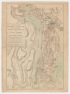
A plan of the operations of the King's army : under the command of General Sr. William Howe, K.B. in New York and east New...
2.
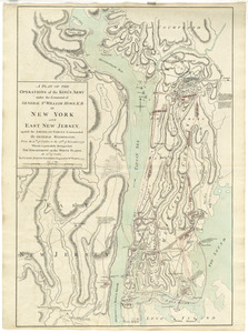
A plan of the operations of the King's army under the command of General Sr. William Howe, K.B. in New York and east New Jersey...
3.
A plan of the operations of the King's army under the command of General Sr. William Howe, K.B. in New York and east New Jersey...
4.
Plan von den operationen der Koeniglichen Armee unter dem General Sir William Howe : in Neuyorck und Ost-Neujerseÿ gegen die...
5.
Plan von den operationen der Koeniglichen Armee unter dem General Sir William Howe : in Neuyorck und Ost-Neujerseÿ gegen die...
6.
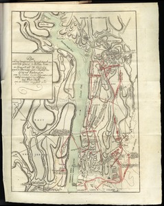
A plan of the country from Frogspoint to Croton River shewing the positions of the American and British armies from the 12th of...
7.
A New and accurate map of the present seat of war in North America, comprehending New Jersey, Philadelphia, Pensylvania,...
8.
A new and accurate map of the province of New York and part of the Jerseys, New England and Canada, shewing the scenes of our...
9.
A plan of New York Island, with part of Long Island, Staten Island & east New Jersey, with a particular description of the...
10.
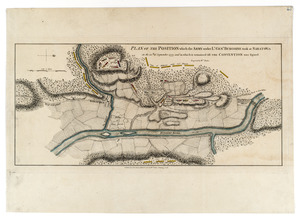
Plan of the position which the army under Lt. Genl. Burgoine took at Saratoga on the 10th of September, 1777, and in which it...
11.
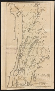
The Country twenty five miles round New York
12.
The seat of war, in New England, by an American volunteer : with the marches of the several corps sent by the colonies, towards...
13.
Position du camp de l'armée combinée a Philipsburg du 6 juillet au 19 aoust
14.
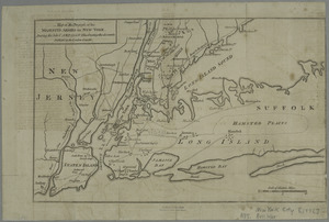
Skecth [sic] of the road from Kings Bridge to White Plains
15.
A plan of New York Island, and part of Long Island, with the circumjacent country, as far as Dobbs's Ferry to the north, and...
16.
A map of the country in which the army under Lt. General Burgoyne acted in the campaign of 1777 : shewing the marches of the...
17.
Map of the progress of His Majesty's armies in New York, during the late campaign : illustrating the accounts published in the...
18.
A new and correct map, of the country in which the Army, under Lt. Gl. Burgoyne acted in 1777, shewing all the places where the...
19.
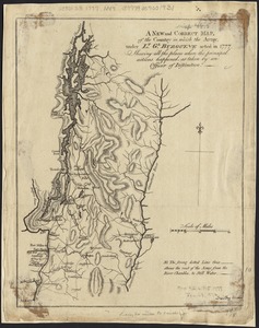
[Plan of the battles of Saratoga]
20.
Chart and plan of the harbour of New York & the couny. adjacent, from Sandy Hook to Kingsbridge, comprehending the whole of New...
‹ Prev
Next ›
1
2
3
4
5


![Skecth [sic] of the road from Kings Bridge to White Plains](https://bpldcassets.blob.core.windows.net/derivatives/images/commonwealth:q524n8895/image_thumbnail_300.jpg)


![[Plan of the battles of Saratoga]](https://bpldcassets.blob.core.windows.net/derivatives/images/commonwealth:z603vw07d/image_thumbnail_300.jpg)
