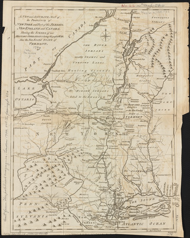
A new and accurate map of the province of New York and part of the Jerseys, New England and Canada, shewing the scenes of our military operations during the present war : also the new erected state of Vermont
This map is also available in American Revolutionary Geographies Online (ARGO), a collections portal especially built for material relating to the American Revolutionary War Era. Visit ARGO to learn more about this item and explore the historical geography of North America in the late eighteenth century.
Item Information
- Title:
- A new and accurate map of the province of New York and part of the Jerseys, New England and Canada, shewing the scenes of our military operations during the present war : also the new erected state of Vermont
- Creator:
- Lodge, John, d. 1796
- Name on Item:
-
Jno. Lodge sculp.
- Date:
-
1780
- Format:
-
Maps/Atlases
- Location:
-
Boston Public Library
Norman B. Leventhal Map & Education Center - Collection (local):
-
Norman B. Leventhal Map & Education Center Collection
- Subjects:
-
New York (State)--History--Revolution, 1775-1783--Maps--Early works to 1800
New Jersey--History--Revolution, 1775-1783--Maps--Early works to 1800
New England--History--Revolution, 1775-1783--Maps--Early works to 1800
Canada--History--1775-1783--Maps--Early works to 1800
Vermont--History--Revolution, 1775-1783--Maps--Early works to 1800
Northeastern States--History--18th century--Maps--Early works to 1800
- Places:
-
New England (area)
Northeastern United States (area)
Vermont
New Jersey
Canada
- Extent:
- 1 map ; 37 x 27 cm.
- Terms of Use:
-
No known copyright restrictions.
No known restrictions on use.
- Publisher:
-
London :
J. Bew
- Scale:
-
Scale not given.
- Language:
-
English
- Notes:
-
Relief shown pictorially.
- Identifier:
-
06_01_003217
- Call #:
-
G3716.S3 1780 .L6
- Barcode:
-
39999058999440


