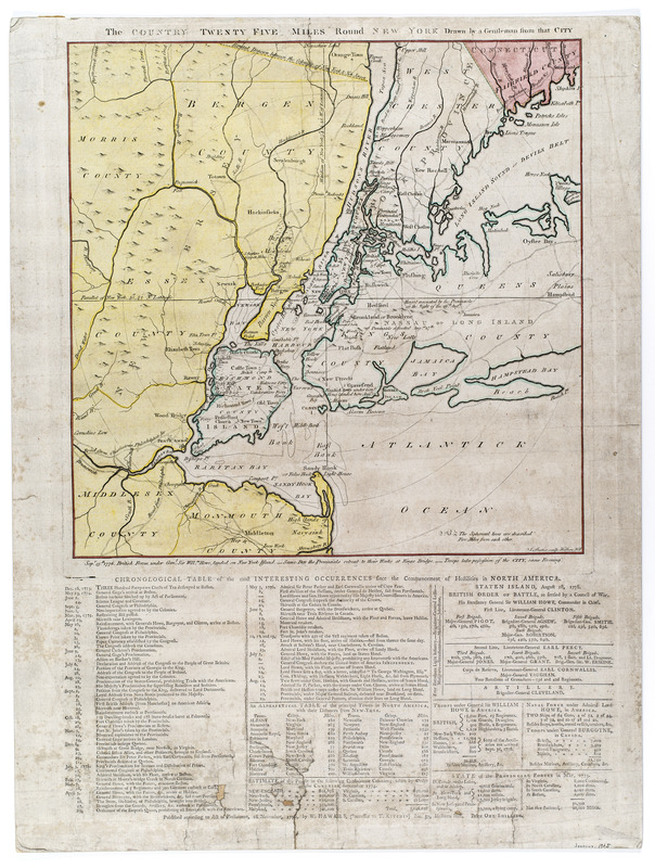
The Country twenty five miles round New York
This map is also available in American Revolutionary Geographies Online (ARGO), a collections portal especially built for material relating to the American Revolutionary War Era. Visit ARGO to learn more about this item and explore the historical geography of North America in the late eighteenth century.
Item Information
- Title:
- The Country twenty five miles round New York
- Title (alt.):
-
Chronological table of the most interesting occurrences since the commencement of hostilities in North America
- Engraver:
- Barber, J.
- Publisher:
- Hawkes, W.
- Name on Item:
-
drawn by a gentleman from that city
- Date:
-
[1776]
- Format:
-
Maps/Atlases
- Location:
- New-York Historical Society
- Collection (local):
-
New-York Historical Society Collection
- Subjects:
-
New York Region--Maps--Early works to 1800
New York Harbor (N.Y. and N.J.)--Maps--Early works to 1800
Long Island, Battle of, New York, N.Y., 1776--Maps--Early works to 1800
United States--History--Revolution, 1775-1783--Maps--Early works to 1800
- Places:
-
New York
- Extent:
- 1 map : color ; 38 x 39 cm, on sheet 61 x 46
- Terms of Use:
-
No known copyright restrictions.
No known restrictions on use.
- Publisher:
-
[London] :
Published according to Act of Parliament, 1st November, 1776, by W. Hawks, (successor to T. Kitchin) no. 59, Holborn Hill ...
- Scale:
-
Scale approximately 1:220,000.
- Language:
-
English
- Catalog Record:
-
https://library.nyu.edu/persistent/lcn/nyu_aleph004266879?institution=NYU&persistent
- Notes:
-
Price one Shilling.
Hand colored.
Relief shown pictorially.
Shows radial distances.
Engraved by: J. Barber, Holborn Hill.
Includes letterpress below map entitled: Chronological table of the most interesting occurrences since the commencement of hostilities in North America.
Letterpress includes chronology of events from Boston Tea Party through Battle of Long Island and provides notes on British military strength.
- Notes (date):
-
This date is inferred.
- Notes (citation):
-
LC Maps of North America, 1750-1789, 1096
Stevens and Tree. Comparative cartography, 43a
- Identifier:
-
42790_Country25MilesNY1776_M25_5_39


