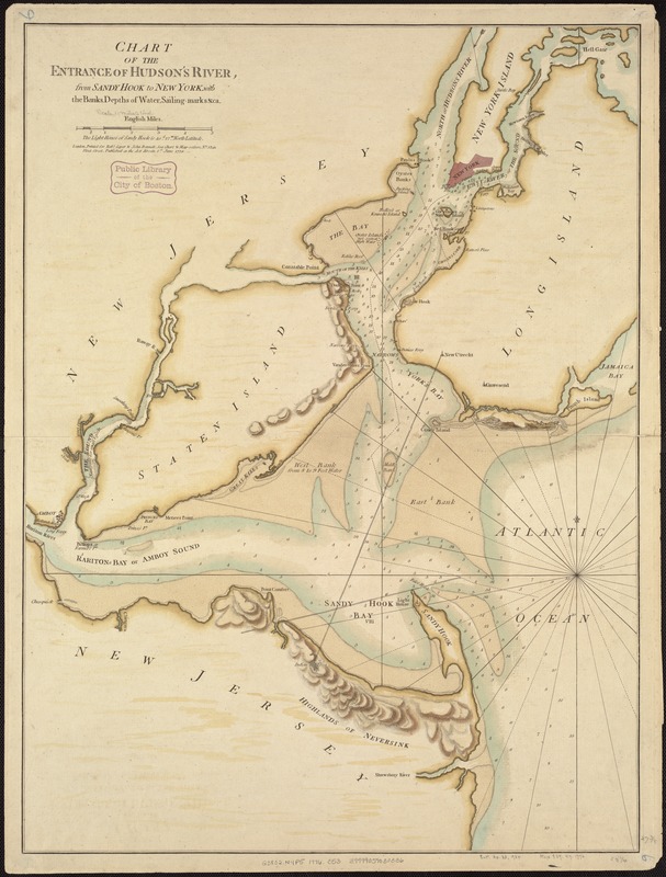
Chart of the entrance of Hudson's River, from Sandy Hook to New York, with the banks, depths of water, sailing-marks, & ca
This map is also available in American Revolutionary Geographies Online (ARGO), a collections portal especially built for material relating to the American Revolutionary War Era. Visit ARGO to learn more about this item and explore the historical geography of North America in the late eighteenth century.
Item Information
- Title:
- Chart of the entrance of Hudson's River, from Sandy Hook to New York, with the banks, depths of water, sailing-marks, & ca
- Date:
-
1776
- Format:
-
Maps/Atlases
- Location:
-
Boston Public Library
Norman B. Leventhal Map & Education Center - Collection (local):
-
Norman B. Leventhal Map & Education Center Collection
- Subjects:
-
Nautical charts--Hudson River Estuary (N.Y. and N.J.)--Early works to 1800
Nautical charts--Upper Bay (N.Y. and N.J.)--Early works to 1800
Nautical charts--Lower Bay (N.Y. and N.J.)--Early works to 1800
New York Region--Maps--Early works to 1800
New York Harbor (N.Y. and N.J.)--Maps--Early works to 1800
Hudson River (N.Y. and N.J.)--Maps--Early works to 1800
- Places:
-
Hudson River
Upper Bay
Lower Bay
- Extent:
- 1 map : col. ; 70 x 52 cm.
- Terms of Use:
-
No known copyright restrictions.
No known restrictions on use.
- Publisher:
-
London :
Printed for Robt. Sayer & John Bennett, sea chart & map-sellers ...
- Scale:
-
Scale [ca. 1:70,000].
- Language:
-
English
- Notes:
-
Depths shown by soundings. Relief shown by hachures.
Appears in The North-American pilot for New England, New York, Pensilvania, Maryland, and Virginia. 1777.
"Published as the Act directs ..."
Watermarks.
Includes note.
- Identifier:
-
06_01_007248
- Call #:
-
G3802.N4P5 1776 .C53
- Barcode:
-
39999059030336