Toggle navigation
LMEC Home
Exhibitions
Georeferencing
Tools for Teachers
Collections
My Favorites
Sign Up / Log In
Search
Search the map portal
Map Collection
Map Collection
Map Sets
Search
Search
Search for
Search In
All Fields
Creator
Title
Subject
Place
Search All Digital Collections
Advanced Search
8172 Results
My Search
Start Over
More Like
commonwealth:kk91fr04q
Remove constraint More Like: commonwealth:kk91fr04q
Filter your Search
Place
North and Central America
4,921
United States
3,610
Suffolk (county)
1,026
Boston
999
Europe
963
Canada
427
France
269
Massachusetts
249
more
Place
»
Topic
Boston (Mass.)--Maps
574
United States--Maps
270
Real property--Massachusetts--Boston--Maps
174
Massachusetts--Maps
160
Landowners--Massachusetts--Boston--Maps
132
North America--Maps--Early works to 1800
103
New England--Maps
99
Europe--Maps
78
more
Topic
»
Date
Date range begin
–
Date range end
Current results range from
1482
to
2023
View distribution
Creator
United States. Hydrographic Office
357
O.H. Bailey & Co
148
Des Barres, Joseph F. W. (Joseph Frederick Wallet), 1722-1824
124
United States. Post Office Dept
120
Ptolemy, 2nd cent
100
Walling, Henry Francis, 1825-1888
94
Jefferys, Thomas, -1771
85
Geological Survey (U.S.)
82
more
Creator
»
Format
Maps/Atlases
8,113
Manuscripts
216
Prints
51
Books
36
Objects/Artifacts
10
Drawings/Illustrations
8
Posters
4
Georeferenced
Yes
869
No
7,303
Collection
Norman B. Leventhal Map Center Collection
8,162
Boston and New England Maps
2,184
Urban Maps
1,925
Maritime Charts and Atlases
751
American Revolutionary War-Era Maps
623
Boston Redevelopment Authority Collection
86
Richard H. Brown Revolutionary War Map Collection at Mount Vernon
4
New York Public Library Collection
3
more
Collection
»
Available to use
No known restrictions
8,022
Creative Commons license
55
Search Constraints
Sort by relevance
relevance
title
date (asc)
date (desc)
Number of results to display per page
20 per page
10
per page
20
per page
50
per page
100
per page
View results as:
grid view
map view
Search Results
1.
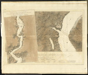
A draught of New York from the Hook to New York Town
2.
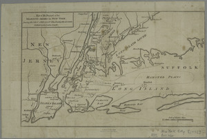
The Country twenty five miles round New York
3.
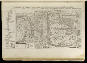
A prospective view of the battle fought near Lake George, on the 8th of Sepr. 1755, between 2000 English, with 250 Mohawks,...
4.
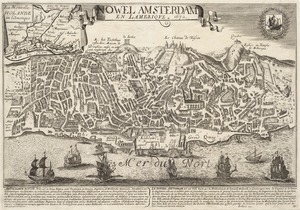
Nowel Amsterdam en Lamerique : 1672
5.
Sketch of the country illustrating the late engagement in Long Island
6.
Particular draughts and plans of some of the principal towns and harbours belonging to the English, French, and Spaniards, in...
7.
Plans des isles, rades, et ports de plusieurs lieux de l'Amérique : tirés de la Carte angloise de Mr. Popple publiée en 1733...
8.
Caroline méridionale et partie de la Georgie
9.
A plan of Fort Montgomery & Fort Clinton, taken by His Majesty's forces, under the command of Maj. Genl. Sir Henry Clinton, K:B
10.
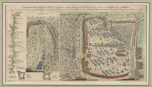
A prospective view of the battle fought near Lake George, on the 8th of Sepr. 1755, between 2000 English, with 250 Mohawks,...
11.
Map of the progress of His Majesty's armies in New York, during the late campaign : illustrating the accounts published in the...
12.
Position du camp de l'armée combinée a Philipsburg du 6 juillet au 19 aoust
13.
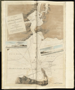
A chart of New York Harbour with the soundings views of land marks and nautical directions : for the use of pilotage
14.
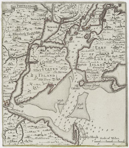
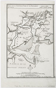
New York and Perthamboy Harbours
15.
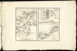
Ports de la Nouvelle York et de Pertamboy -- Plan de la ville et du port de Charles Town dans la Caroline Méridionale -- I. de...
16.
Ports de la Nouvelle York et Pertamboy : aux anglois
17.
The 100th anniversary map of Abraham Lincoln's visit to Massachusetts, September 11-23, 1848
18.
1630 shoreline
19.
1879. Progress map of the U.S. Geographical Surveys west of the 100th Meridian : prepared under the direction of 1st Lieut....
20.
1903 Map of Salem and surrounding places
‹ Prev
Next ›
1
2
3
4
5
…
408
409