A draught of New York from the Hook to New York Town
Item Information
- Title:
- A draught of New York from the Hook to New York Town
- Description:
-
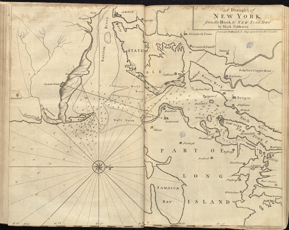
This chart of the entrance to New York was included in the 1737 edition of The English Pilot: The Fourth Book. Tiddeman's chart served as the standard chart of the area for nearly fifty years, until the publication of The Atlantic Neptune. This chart includes rough depictions of topography along the coastline, in the form of hachures, or lines. These lines were intended to give the navigator a sense of height, such as cliffs or other tall landforms. Compared to the detailed and finely executed headland views of the same area in The Atlantic Neptune, Tiddeman's version is crude, and less instructive.
- Creator:
- Tiddeman, Mark.
- Name on Item:
-
by Mark Tiddeman.
- Date:
-
[1737]
- Format:
-
Maps/Atlases
- Location:
-
Boston Public Library
Norman B. Leventhal Map & Education Center - Collection (local):
-
Norman B. Leventhal Map & Education Center Collection
- Subjects:
-
Nautical charts--Raritan Bay (N.J. and N.Y.)--Early works to 1800
Nautical charts--Lower Bay (N.Y. and N.J.)--Early works to 1800
New York Region--Maps--Early works to 1800
- Places:
-
Lower Bay
Raritan Bay
- Extent:
- 1 map ; 45 x 57 cm.
- Terms of Use:
-
No known copyright restrictions.
No known restrictions on use.
- Publisher:
-
London :
Printed for W. Mount & T. Page
- Scale:
-
Scale [ca. 1:100,000]
- Language:
-
English
- Notes:
-
Covers Amboy east to Jamaica Bay and from Harlem south to Shrewsbury River.
Depths shown by soundings.
Oriented with north to the right.
In the English pilot, the fourth book. London : Printed for William Mount and Thomas Page, 1737.
- Notes (date):
-
This date is inferred.
- Notes (exhibitions):
-
Exhibited: "Charting an Empire: The Atlantic Neptune" organized by the Norman B. Leventhal Map Center at the Boston Public Library, 2013.
- Identifier:
-
06_01_010267
- Call #:
-
G1106.P5 E54 1737
- Barcode:
-
30000003249882