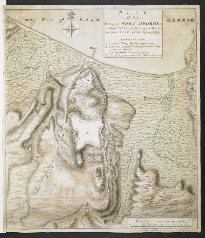
PLAN of the Designed FORT GEORGE at present executing, Shewing its situation and part of its Environs. July the 17.th 1759
This map is also available in American Revolutionary Geographies Online (ARGO), a collections portal especially built for material relating to the American Revolutionary War Era. Visit ARGO to learn more about this item and explore the historical geography of North America in the late eighteenth century.
Item Information
- Title:
- PLAN of the Designed FORT GEORGE at present executing, Shewing its situation and part of its Environs. July the 17.th 1759
- Cartographer:
- Brasier, William
- Former owner:
- Amherst, Jeffery Amherst, Baron, 1717-1797
- Former owner:
- Royal United Services Institute for Defence and Security Studies
- Name on Item:
-
Camp at Lake George, W. Brasier Draughtsman to the Ch: Engnr Surv.r & Del.t.
- Date:
-
1759
- Format:
-
Maps/Atlases
- Location:
- British Library
- Collection (local):
-
British Library Collection
- Subjects:
-
Fortification--New York (State)--Lake George--Maps, Manuscript--Early works to 1800
Military art and science--New York (State)--Lake George--Maps, Manuscript--Early works to 1800
Lake George (N.Y.)--Maps, Manuscript--Early works to 1800
- Places:
-
Warren (county)Lake George
- Extent:
- 1 map : manuscript pen and ink with watercolour ; 45 x 39 cm
- Terms of Use:
-
No known copyright restrictions.
This work is licensed for use under a Creative Commons Attribution Non-Commercial Share Alike License (CC BY-NC-SA).

- Publisher:
-
Camp at Lake George :
W. Brasier Draughtsman to the Ch: Engnr Surv.r & Del.t.,
- Scale:
-
Scale approximately 1:2,400
- Language:
-
English
- Catalog Record:
-
http://searcharchives.bl.uk/IAMS_VU2:IAMS040-001999744
- Notes:
-
Relief shown by shading and by hachuring.
Shows title in simple surround at upper left, also containing lettered key (A-D).
Shows the design for the completed outline of Fort George, whilst still under construction. The key highlights the fort is not yet complete - "Designed Fort, the Foundation laid".
Shows "Road from Fort Edward to Lake George".
Shows scale bar at lower right, "Scale 200 feet to an Inch".
Illustrates felled trees on surrounding land pictorially (used for the fort's construction?).
Signed in the margin at lower right.
Copy at Add Ms 57,712.6. Bound in R.U.S.I. Vol LXXVII. Shows manuscript addition of "6" in pencil at upper right. Shows "A 39" in pencil at lower right and "A 30/41C" in pencil at upper right. Laid on archival tissue. Green circular label to verso shows "17+". White label to verso shows "DRAWER 30 SECTION 1". Blue label to verso shows "A 30/41C".
- Notes (date):
-
9999