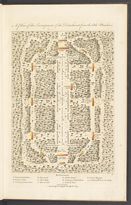
A plan of the encampment of the detachment from the Little Meadows
This map is also available in American Revolutionary Geographies Online (ARGO), a collections portal especially built for material relating to the American Revolutionary War Era. Visit ARGO to learn more about this item and explore the historical geography of North America in the late eighteenth century.
Item Information
- Title:
- A plan of the encampment of the detachment from the Little Meadows
- Contributor:
- Jefferys, Thomas, -1771
- Creator:
- Orme, Robert, -1781
- Date:
-
[1758]
- Format:
-
Maps/Atlases
- Location:
- William L. Clements Library
- Collection (local):
-
William L. Clements Library Collection
- Subjects:
-
Braddock's Campaign, 1755--Maps
Military camps--Maps
United States--History--French and Indian War, 1754-1763--Maps
- Places:
-
Pennsylvania
Maryland
Virginia
- Extent:
- 1 map : col. ; 28.6 x 20.8 cm.
- Terms of Use:
-
The University of Michigan Library provides access to these materials for educational and research purposes. These materials may be under copyright. If you decide to use any of these materials, you are responsible for making your own legal assessment and securing any necessary permission. If you have questions about the collection, please contact the William L. Clements Library.
Contact host institution for more information.
- Publisher:
-
[London] :
[Printed for T. Jefferys at Charing Cross]
- Scale:
-
Scale 1:3.240.
- Language:
-
English
- Catalog Record:
-
Catalog record
- Notes:
-
In: [Six plans of the different dispositions of the English army ...], 1758.
Detailed plan of the nightly camp of Braddock's army with the detachments deployed for its protection.
Below neat line at right: IV.
- Notes (date):
-
This date is inferred.
- Identifier:
-
1667
- Barcode:
-
B1939349