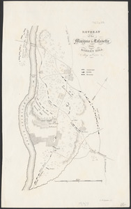
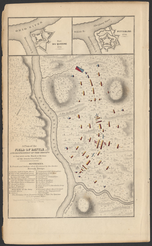
A plan of the field of battle and disposition of the troops as they were on the march at the time of the attack, July 9th, 1755
Item Information
- Title:
- A plan of the field of battle and disposition of the troops as they were on the march at the time of the attack, July 9th, 1755
- Engraver:
- Smith, George Girdler, 1795-1878
- Name on Item:
-
Engraved ... by George G. Smith
- Date:
-
1853
- Format:
-
Maps/Atlases
- Location:
-
Phillips Academy
Archives and Special Collections - Collection (local):
-
Ralph Finos Map Collection
- Subjects:
-
Campaigns & battles
War
United States--History--French and Indian War, 1754-1763
- Places:
-
Monongahela River
Ohio River
PennsylvaniaWest Branch Susquehanna River
- Extent:
- 1 map ; 20 x 13 cm
- Terms of Use:
-
We believe that this item has no known US copyright restrictions. Though not required, if you want to credit us as the source, please use the following statement, "From The Trustees of Phillips Academy." Doing so helps us track how our collection is used and helps justify freely releasing even more content in the future.
This work is in the public domain under a Creative Commons No Rights Reserved License (CC0).
- Scale:
-
Scale not given.
- Language:
-
English
- Notes:
-
Title from item.
From History of the United States from the discovery of the American continent, vol. 4, 1853.
Inset maps: Fort Du Quesne, 1755; Pittsburg, 1759.
- Notes (date):
-
Date supplied by cataloger.
- Identifier:
-
2018_114