Toggle navigation
LMEC Home
Exhibitions
Georeferencing
Tools for Teachers
Collections
My Favorites
Sign Up / Log In
Search
Search the map portal
Map Collection
Map Collection
Map Sets
Search
Search
Search for
Search In
All Fields
Creator
Title
Subject
Place
Search All Digital Collections
Advanced Search
8174 Results
My Search
Start Over
More Like
commonwealth:x633f945h
Remove constraint More Like: commonwealth:x633f945h
Filter your Search
Place
North and Central America
4,923
United States
3,613
Suffolk (county)
1,026
Boston
999
Europe
963
Canada
427
France
269
Massachusetts
249
more
Place
»
Topic
Boston (Mass.)--Maps
574
United States--Maps
270
Real property--Massachusetts--Boston--Maps
174
Massachusetts--Maps
160
Landowners--Massachusetts--Boston--Maps
132
North America--Maps--Early works to 1800
103
New England--Maps
99
Europe--Maps
78
more
Topic
»
Date
Date range begin
–
Date range end
Current results range from
1482
to
2023
View distribution
Creator
United States. Hydrographic Office
357
O.H. Bailey & Co
148
Des Barres, Joseph F. W. (Joseph Frederick Wallet), 1722-1824
125
United States. Post Office Dept
120
Ptolemy, 2nd cent
100
Walling, Henry Francis, 1825-1888
94
Jefferys, Thomas, -1771
84
Geological Survey (U.S.)
82
more
Creator
»
Format
Maps/Atlases
8,115
Manuscripts
219
Prints
51
Books
36
Objects/Artifacts
10
Drawings/Illustrations
8
Posters
4
Georeferenced
Yes
869
No
7,305
Collection
Norman B. Leventhal Map Center Collection
8,168
Boston and New England Maps
2,189
Urban Maps
1,925
Maritime Charts and Atlases
757
American Revolutionary War-Era Maps
626
Boston Redevelopment Authority Collection
86
Mapping Boston Collection
6
Library of Congress Collection
5
more
Collection
»
Available to use
No known restrictions
8,021
Creative Commons license
58
Search Constraints
Sort by relevance
relevance
title
date (asc)
date (desc)
Number of results to display per page
100 per page
10
per page
20
per page
50
per page
100
per page
View results as:
grid view
map view
Search Results
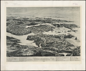
7901.
Vinalhaven, Me : 1893
7902.
Vineyard Haven, Dukes County, Martha's Vineyard, Massachusetts : the popular seaside summer resort
7903.
Vineyard Sound and Buzzards Bay, Massachusetts
7904.
Virginia
7905.
Virginia
7906.
Virginia
7907.
Virginia and Maryland
7908.
Virginia, Maryland, Pennsilvania, east & west New Jarsey
7909.
Virginia Marylandia et Carolina in America septentrionali Brittannorum industria excultæ
7910.
Virginiae item et Floridae Americae provincarum, nova descriptio
7911.
Virginiae item et Floridae Americae provinciarum, nova descriptio
7912.
Virginiae partis australis et Floridae partis orientalis, interjacentium[que] regionum nova descriptio
7913.
Virginiae partis australis, et Floridae partis orientalis, interjacentiumq[ue] regionum nova descriptio
7914.
A vision of Private Kutschkes of the German National Guard = Traumgebild des deutschen Landwehrmanns Kutschke!
7915.
Vltoniae orientalis : pars
7916.
Vmbria overo ducato di Spoleto
7917.
Völker und sprachen-karte von Deutschland und den nachbarländern im j. 1867
7918.
Volunteer militia and eastern army guide : One hundred and fifty miles around Richmond
7919.
Vom Rhein bis Paris
7920.
Vorstellung einiger Gegenden und Plaetze in Nord-America unter Franzoesisch und Englische Jurisdiction gehoerig
7921.
Vtriusque Castellae nova descriptio
7922.
La vue a vol d'oiseau de l'Abbaye de Saint-Martin de Laon (de l'Ordre de Prémontré)
7923.
Vue de Quebec, capitale du Canada
7924.
Vue du Port-au-Prince et ses environs
7925.
W. & A.K. Johnston's map to illustrate the Chinese question
7926.
W. & A.K. Johnston's maps to illustrate the Niger and Upper Nile questions
7927.
Wage map no. 1 - Polk Street to Twelfth, Halsted Street to Jefferson, Chicago ; Wage map no. 2 - Polk Street to Twelfth,...
7928.
Wage map no. 3 - Polk Street to Twelfth, Beach Street to Pacific Avenue, Chicago ; Wage map no. 4 - Polk Street to Twelfth,...
7929.
Wahre Bildtnüé der vesten Statt Montavban und wie dieselbe von Königl. Maÿ. in Franckreich belägert worden Anno 1621
7930.
Wakefield and Peace Dale, Rhode Island : 1888
7931.
Wakefield, Massachusetts : diagram showing the first ten miles of the Boston & Maine Railroad
7932.
Wakes Island ; Vatoa or Turtle Island and Vuata Vatoa ; Taloo Harbour, Island of Eimeo
7933.
Die Walachei
7934.
Waldoboro, Lincoln County, Maine, 1896
7935.
Wales
7936.
Walling and Gray's map of the United States and territories
7937.
Wallis's plan of the cities of London & Westminster
7938.
Wallis's tour through the United Kingdom of England, Scotland and Ireland, a new geographical game, comprehending all the...
7939.
Wallowa National Forest, Oregon
7940.
Walpole, Massachusetts : 1882
7941.
Waltham, 1911
7942.
Walworth County, Wis.
7943.
War chart of the Southern States showing the towns, rivers, rail-roads and common roads
7944.
War map no. 2 : northern Italy
7945.
War map of Central Europe from Paris to Vienna
7946.
War map of the Rhine frontiers
7947.
War maps and diagrams
7948.
War maps of Cuba, Porto Rico, and the Philippines
7949.
War telegram marking map
7950.
Ward 1 [of Boston]
7951.
Ward boundaries 1959
7952.
Ward lines and voting precincts 1954
7953.
Ward lines and voting precincts circa 1945
7954.
Wards & precincts, city of Boston - 1890
7955.
Warner, N.H : 1887
7956.
Warren
7957.
Warren, Rhode Island
7958.
Warren, Worcester County, Massachusetts, November 1911 : including West Warren
7959.
Warwicum, Northamtonia, Huntingdonia, Cantabrigia, Suffolcia, Oxonium, Buckinghamia, Bedfordia, Hartfordia, Essexia, Berceria,...
7960.
Washakie National Forest, Wyoming
7961.
Washington
7962.
Washington & its vicinity
7963.
Washington & Ozaukee Counties, Wis.
7964.
Washington and Marion counties
7965.
Washington and vicinity
7966.
Washington, Rhode Island : 1888
7967.
Washington Sound and approaches, Washington Territory, 1866
7968.
Washington Street boulevard study : generalized land use - proposed
7969.
Washington Street boulevard study : proposed fabric
7970.
Washington Street boulevard study : corridor wide urban design strategy
7971.
Washington Street corridor : South Cove to Forest Hills
7972.
Washington Territory
7973.
Wastewater system map, Boston proper, sheet no. 23h
7974.
Water shed of the Passaic River
7975.
Waterfront skyline
7976.
Waupaca County, Wis.
7977.
Waushara, Marquette, and Green Lake Counties, Wis.
7978.
We must have order
7979.
Weiterführung der Rheinischen Eisenbahn : general übersicht
7980.
Weller's political map of the United States : showing the plurality vote of the presidential election of 1892, in all states...
7981.
Welt-karte zur übersicht der meeres-strömungen und des schnellverkehrs
7982.
West Boylston, Massachusetts : 1891
7983.
West Brookfield
7984.
West Canton Community Park
7985.
West coast of Korea, Ping Yang Inlet
7986.
West End of the Isle of Sable from the northward ... : Wreckers Den near the Pond ... ; North Shore ; North Shore of Isle Sable
7987.
West India islands
7988.
West India Islands
7989.
The West India Islands and adjacent territory showing British possessions south of the United States
7990.
The West Indian atlas [frontispiece] : or, a general description of the West Indies
7991.
West Indien und Mittel America
7992.
The West Indies
7993.
West Indies
7994.
West Indies, anchorages on the north coast of Cuba
7995.
The West Indies and coast adjacent : reduced from the sheet map
7996.
West Indies, Antigua, Falmouth and English Harbors : from British surveys corrected to 1872
7997.
West Indies, Bahamas, Port Nelson, Rum Cay : from a survey in 1886 by the officers of the U.S. Fish Commission Steamer...
7998.
West Indies, Cuba, Cabonico and Livisa : from a Spanish survey
7999.
West Indies, Cuba, Jururu : from a Spanish survey
8000.
West Indies, Cuba, Nipe : from a Spanish survey
‹ Prev
Next ›
1
2
…
76
77
78
79
80
81
82