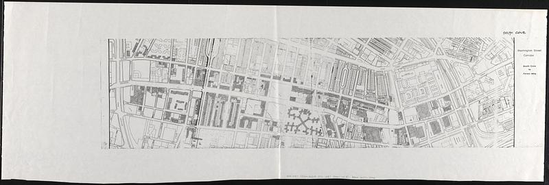
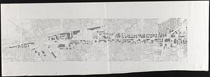
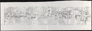
Washington Street corridor : South Cove to Forest Hills

Item Information
- Title:
- Washington Street corridor : South Cove to Forest Hills
- Date:
-
[1970–1979]
- Format:
-
Maps/Atlases
- Location:
-
Boston Public Library
Norman B. Leventhal Map & Education Center - Collection (local):
-
Norman B. Leventhal Map & Education Center Collection
- Series:
- Boston Redevelopment Authority Maps & Manuscript Plans Collection
- Subjects:
-
Washington Street (Boston, Mass.)--Maps
Jamaica Plain (Boston, Mass.)--Maps
Roxbury (Boston, Mass.)--Maps
South End (Boston, Mass.)--Maps
Buildings--Massachusetts--Boston--Maps
- Places:
-
MassachusettsSuffolk (county)BostonJamaica Plain
MassachusettsSuffolk (county)BostonRoxbury
MassachusettsSuffolk (county)BostonSouth End
- Extent:
- 1 map on 3 sheets ; sheets 48 x 136 cm or smaller
- Terms of Use:
-
No known copyright restrictions.
No known restrictions on use.
- Scale:
-
Scale approximately 1:2,400
- Language:
-
English
- Notes:
-
Oriented with north to the upper right.
Shows the area around Washington St. from Herald St. in South End to Walk Hill St. in Jamaica Plain.
Shows lots and building footprints, with some buildings shaded or added in pencil.
- Notes (date):
-
This date is inferred.
- Identifier:
-
06_01_017899A
06_01_017899B
06_01_017899C
- Call #:
-
BRA MAP FOLDER 29
- Barcode:
-
30000007770995

![[Plan of boundary lines in Roxbury and the City of Boston]](https://bpldcassets.blob.core.windows.net/derivatives/images/commonwealth:1257bb127/image_thumbnail_300.jpg)


