Toggle navigation
LMEC Home
Exhibitions
Georeferencing
Tools for Teachers
Collections
My Favorites
Sign Up / Log In
Search
Search the map portal
Map Collection
Map Collection
Map Sets
Search
Search
Search for
Search In
All Fields
Creator
Title
Subject
Place
Search All Digital Collections
Advanced Search
8871 Results
My Search
Start Over
More Like
commonwealth:0c4863041
Remove constraint More Like: commonwealth:0c4863041
Filter your Search
Place
North and Central America
6,102
United States
5,020
Massachusetts
2,126
Europe
1,396
Suffolk (county)
1,222
Boston
1,195
Canada
449
Asia
438
more
Place
»
Topic
Boston (Mass.)--Maps
613
United States--Maps
282
Real property--Massachusetts--Boston--Maps
228
City planning--Massachusetts--Boston--Maps
200
Landowners--Massachusetts--Boston--Maps
168
Massachusetts--Maps
162
Buildings--Massachusetts--Boston--Maps
125
Urban renewal--Massachusetts--Boston--Maps
112
more
Topic
»
Date
Date range begin
–
Date range end
Current results range from
1482
to
2023
View distribution
Creator
United States. Hydrographic Office
595
Boston Redevelopment Authority
200
O.H. Bailey & Co
148
Des Barres, Joseph F. W. (Joseph Frederick Wallet), 1722-1824
123
United States. Post Office Dept
120
Ptolemy, 2nd cent
100
Walling, Henry Francis, 1825-1888
94
Geological Survey (U.S.)
86
more
Creator
»
Format
Maps/Atlases
8,811
Manuscripts
215
Prints
56
Books
36
Objects/Artifacts
10
Drawings/Illustrations
8
Posters
5
Georeferenced
Yes
871
No
8,000
Collection
Norman B. Leventhal Map & Education Center Collection
8,697
Boston and New England Maps
2,375
Urban Maps
2,164
Maritime Charts and Atlases
1,083
American Revolutionary War-Era Maps
616
Boston Redevelopment Authority Collection
226
Massachusetts Real Estate Atlases
34
Applied Geographics, Inc. Records
2
more
Collection
»
Available to use
No known restrictions
8,694
Creative Commons license
48
Search Constraints
Sort by relevance
relevance
title
date (asc)
date (desc)
Number of results to display per page
20 per page
10
per page
20
per page
50
per page
100
per page
View results as:
grid view
map view
Search Results
1.
View of the South End
2.
[Plan of boundary lines in Roxbury and the City of Boston]
3.
Atlas of the city of Boston : Roxbury : from actual surveys and official plans
4.
Atlas of the city of Boston : Roxbury : from actual surveys and official plans
5.
Atlas of the city of Boston : Roxbury : from actual surveys and official plans
6.
Atlas of the city of Boston : Roxbury : from actual surveys and official plans
7.
Atlas of the city of Boston : Roxbury : volume two : from actual surveys and official records
8.
Atlas of the city of Boston : Roxbury, Mass. : volume three : from actual surveys and official records
9.
Atlas of the city of Boston : West Roxbury : volume five : from actual surveys and official records
10.
Atlas of the county of Suffolk, Massachusetts : vol. 2nd late city of Roxbury, now wards 13-14 and 15, city of Boston
11.
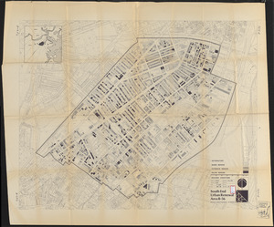
Illustrative site plan : South End urban renewal area, Massachusetts r-56
12.
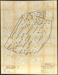
South End project no. Mass. r-56 : building deficiencies
13.
South End urban renewal area R-56 : re-use parcels
14.
South End urban renewal area R-56 : re-use parcels
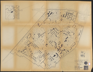
15.
South End urban renewal area R-56 : illustrative site plan
16.
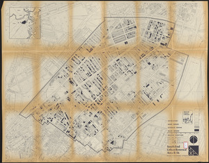
South End urban renewal area R-56 : building conditions
17.
South End urban renewal area R-56 : building conditions
18.
Jamaica Plain urban renewal area r-49 : building conditions
19.
Atlas of the city of Boston : Boston proper and Roxbury
20.
Atlas of the city of Boston : Roxbury
‹ Prev
Next ›
1
2
3
4
5
…
443
444

![[Plan of boundary lines in Roxbury and the City of Boston]](https://bpldcassets.blob.core.windows.net/derivatives/images/commonwealth:1257bb127/image_thumbnail_300.jpg)