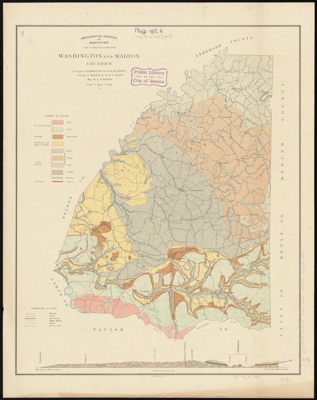
Washington and Marion counties
Item Information
- Title:
- Washington and Marion counties
- Title (alt.):
-
Report on the geology of Washington County
Report on the geology of Marion County
- Creator:
- Hoeing, J. B. (Joseph Bernard), 1855-
- Name on Item:
-
map by J.B. Hoeing.
- Date:
-
[1882]
- Format:
-
Maps/Atlases
- Location:
-
Boston Public Library
Norman B. Leventhal Map & Education Center - Collection (local):
-
Norman B. Leventhal Map & Education Center Collection
- Subjects:
-
Geology--Kentucky--Washington County--Maps
Geology--Kentucky--Marion County--Maps
Washington County (Ky.)--Maps
Marion County (Ky.)--Maps
- Places:
-
KentuckyWashington (county)
KentuckyMarion (county)
- Extent:
- 1 map : color ; 54 x 44 cm
- Terms of Use:
-
No known copyright restrictions.
No known restrictions on use.
- Publisher:
-
[Frankfort, Ky.] :
Geological Survey of Kentucky
- Scale:
-
Scale [1:126,720]. 2 miles = 1 in.
- Language:
-
English
- Notes:
-
Shows railroads, houses, and Indian mounds.
Detached from: Report on the geology of Washington County / W.M. Linney. Frankfort, Ky.: Geological Survey of Kentucky, [1882]. Detached from: Report on the geology of Marion County / W.T. Knott. [Frankfort, Ky.]: Geological Survey of Kentucky, [1883].
"Julius Bien & Co., Lith., N.Y."
Includes 1 horizontal section running from Chaplin River to Muldrow's Hill. Scale 1:126,720. Vertical scale 1:14,000.
- Notes (date):
-
This date is inferred.
- Identifier:
-
06_01_011047
- Call #:
-
G3953.W3C5 1882 .H64
- Barcode:
-
39999065681858


