Washington Sound and approaches, Washington Territory, 1866
Item Information
- Title:
- Washington Sound and approaches, Washington Territory, 1866
- Description:
-
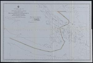
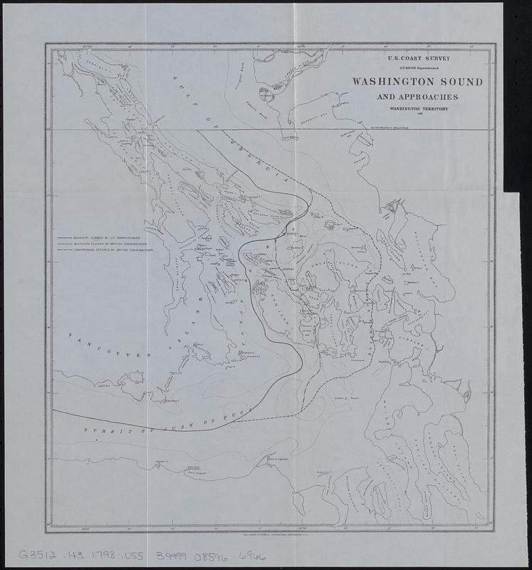
Reproduction of part a map of Washington Sound by the U.S. Coast Survey, showing the area involved in the San Juan boundary dispute between Great Britain and the United States. Shows boundary claimed by the U.S. commissioner, boundary claimed by British commissioner, and compromise offered by British commissioner.
- Cartographer:
- United States Coast Survey
- Contributor:
- Moore, John Bassett, 1860-1947
- Contributor:
- United States. Congress (53rd, 2nd session : 1893-1894). House
- Name on Item:
-
U.S. Coast Survey
- Date:
-
[1898]
- Format:
-
Maps/Atlases
- Location:
-
Boston Public Library
Norman B. Leventhal Map & Education Center - Collection (local):
-
Norman B. Leventhal Map & Education Center Collection
- Subjects:
-
Northwest boundary of the United States--Maps
Canada--Boundaries--United States--Maps
United States--Boundaries--Canada--Maps
British Columbia--Boundaries--Washington (State)--Maps
Washington (State)--Boundaries--British Columbia--Maps
- Places:
-
WashingtonPuget Sound
- Extent:
- 1 map ; 28 x 25 cm
- Terms of Use:
-
No known copyright restrictions.
No known restrictions on use.
- Publisher:
-
[Washington] :
[Government Printing Office]
- Scale:
-
Scale approximately 1:495,000
- Language:
-
English
- Notes:
-
Bathymetry shown by isolines.
"The Norris Peters Co., photo-litho., Washington, D.C."
Detached from House of Representatives 53d congress, 2d session, mis. doc. no. 212. History and digest of the international arbitrations to which the United States has been a party volume I (Washington : Government Printing Office, 1898).
- Notes (date):
-
This date is inferred.
- Identifier:
-
06_01_018405
- Call #:
-
G3512.H3 1798 .U55
- Barcode:
-
39999085966966