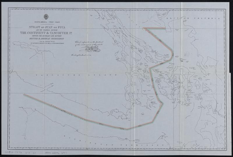
North America--west coast, Strait of Juan de Fuca and the channels between the continent & Vancouver Id. showing the boundary line between British & American possessions : from the Admiralty surveys by Captains H. Kellett, R.N. 1847, & G.H. Richards, R.N. 1858-62
Item Information
- Title:
- North America--west coast, Strait of Juan de Fuca and the channels between the continent & Vancouver Id. showing the boundary line between British & American possessions : from the Admiralty surveys by Captains H. Kellett, R.N. 1847, & G.H. Richards, R.N. 1858-62
- Description:
-
Colored line indicates the northwestern boundary of the U.S. running through the Strait of Juan de Fuca and Strait of Georgia. Angle, direction and distance of lines are given. Includes islands, channels, bays, points, inlets, ports and banks. Also includes extreme northwestern Washington Territory, southern Vancouver Island and southwestern British Columbia. Boundary line drawn from the provisions of the 1871 Treaty of Washington.
- Cartographer:
- Great Britain. Hydrographic Office
- Contributor:
- Moore, John Bassett, 1860-1947
- Cartographer:
- Kellett, Henry, 1806-1875
- Cartographer:
- Richards, G. H. (George Henry)
- Contributor:
- United States. Congress (53rd, 2nd session : 1893-1894). House
- Date:
-
[1898]
- Format:
-
Maps/Atlases
- Location:
-
Boston Public Library
Norman B. Leventhal Map & Education Center - Collection (local):
-
Norman B. Leventhal Map & Education Center Collection
- Subjects:
-
Juan de Fuca, Strait of (B.C. and Wash.)--Maps
Georgia, Strait of (B.C. and Wash.)--Maps
Northwest boundary of the United States--Maps
Canada--Boundaries--United States--Maps
United States--Boundaries--Canada--Maps
British Columbia--Boundaries--Washington (State)--Maps
Washington (State)--Boundaries--British Columbia--Maps
- Places:
-
Georgia, Strait of
Juan de Fuca, Strait of
- Extent:
- 1 map : color ; 36 x 55 cm
- Terms of Use:
-
No known copyright restrictions.
No known restrictions on use.
- Publisher:
-
[Washington] :
[Government Printing Office]
- Scale:
-
Scale approximately 1:330,000
- Language:
-
English
- Notes:
-
Removed from History and digest of the international arbitrations to which the United States has been a party, together with appendices containing the treaties relating to such arbitrations, and historical and legal notes on other international arbitrations ancient and modern, and on the domestic commissions of the United States for the adjustment of international claims / by John Bassett Moore. Washington : G.P.O., 1898. (Mis. Doc. / 53d Congress, 2d Session, House, no. 212).
"Chart referred to in the protocol of the undersigned of this date. Hamilton Fish [signed], Edward Thornton [signed], James C. Prevost [signed]. Washington, March 10, 1873."
"The Norris Peters Co., photo-litho., Washington D.C."
- Notes (date):
-
This date is inferred.
- Identifier:
-
06_01_018400
- Call #:
-
G3512.J8F2 1873 .G7
- Barcode:
-
39999085966917