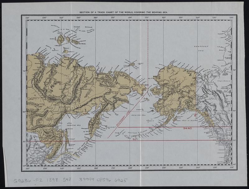
Section of a track chart of the world, covering the Behring Sea
Item Information
- Title:
- Section of a track chart of the world, covering the Behring Sea
- Description:
-
Reproduction of a section of track chart of the world published by the U.S. Hydrographic Office, covering the Pacific Northwest to eastern Russia. Shows boundary line through the Bering Sea and lines at 54°40' and 50° in the Oregon boundary dispute.
- Contributor:
- Moore, John Bassett, 1860-1947
- Cartographer:
- United States. Hydrographic Office
- Contributor:
- United States. Congress (53rd, 2nd session : 1893-1894). House
- Date:
-
[1898]
- Format:
-
Maps/Atlases
- Location:
-
Boston Public Library
Norman B. Leventhal Map & Education Center - Collection (local):
-
Norman B. Leventhal Map & Education Center Collection
- Subjects:
-
Northwest boundary of the United States--Maps
Canada--Boundaries--United States--Maps
United States--Boundaries--Canada--Maps
British Columbia--Boundaries--Washington (State)--Maps
Washington (State)--Boundaries--British Columbia--Maps
- Places:
-
Alaska
Bering Sea
- Extent:
- 1 map : color ; 18 x 25 cm
- Terms of Use:
-
No known copyright restrictions.
No known restrictions on use.
- Publisher:
-
[Washington] :
[Government Printing Office]
- Scale:
-
Scale approximately 1:31,000,000 at 55°N
- Language:
-
English
- Notes:
-
Detached from House of Representatives 53d congress, 2d session, mis. doc. no. 212. History and digest of the international arbitrations to which the United States has been a party volume I (Washington : Government Printing Office, 1898).
- Notes (date):
-
This date is inferred.
- Identifier:
-
06_01_018401
- Call #:
-
G9236.F2 1898 .S43
- Barcode:
-
39999085966925